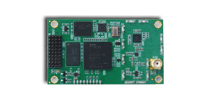
Skip to content

Archives

CSR Launches SiRFstarV 5e GNSS Location Solution

June 10, 2013 - By

CSR plc has debuted the SiRFstarV 5e, a GNSS engine optimized to enable highly accurate location positioning for devices including mobile phones, cameras, and health and fitness products. By supporting fully concurrent GLONASS, GPS, QZSS, and SBAS from ROM, the highest accuracy and fastest time-to-first-fix (TTFF) are ensured. Wireless solutions specialist Telit Communications plc will be using the solution for... read more

This article is tagged with , , , and posted in Product Showcase

Leica Geosystems Launches Mobile Mapping Solution Pegasus:One

June 7, 2013 - By

Leica Geosystems has launched Pegasus:One, a flexible, mobile mapping platform that offers an intuitive mobile mapping solution for professionals. Pegasus:One allows service providers to use their existing terrestrial scanner in profiler mode for mobile mapping. Pegasus:One is vehicle independent and comes self-contained in two Pelican cases, enabling users to fly in, map, and fly out. The Leica Pegasus:One mobile mapping... read more

This article is tagged with , , and posted in Latest News, Mapping, Product Showcase, Survey

Spirent Launches Multi-Frequency GNSS Record and Playback System

June 6, 2013 - By

Spirent Communications’ new  SS6425 multi-frequency GNSS record and playback (RPS) test system provides RF recordings for more constellations (GPS, GLONASS, Galileo, BeiDou, QZSS), more frequencies (L1, L2, L5), wider bandwidth (30MHz) and more features than the company’s previous systems, to support a wide range of positioning and timing test applications. The test system is self-contained and portable, enabling users to... read more

This article is tagged with , and posted in Latest News, OEM, Product Showcase

Leica Infinity Software Released for Nova MS50 Multistation

June 5, 2013 - By

A new office software program, Leica Infinity, has been launched by Leica Geosystems for easy management, visualization, processing and georeferencing of combined total station, imaging and scanning data from the Leica Nova MS50 MultiStation. Part of an extensive portfolio of software that completes the Leica Nova solution, Leica Infinity provides users with custom deliverables and helps them make informed decisions,... read more

This article is tagged with and posted in GIS News, GNSS/GPS, Mobile Devices

Air Force Video Explains GPS Role in Daily Life

June 5, 2013 - By

All of us in the GPS industry know someone who only thinks of GPS as a feature of their smartphone. You might direct them to a new YouTube video presented by the U.S. Air Force, which summarizes the worldwide role of GPS. It also touches on the GPS modernization program and new signals. The seven-minute video explains in simple terms... read more

This article is tagged with , , , and posted in Defense, GNSS, Latest News

Ortho Imagery: Pay or Play Free?

June 5, 2013 - By

By Art Kalinksi Several weeks ago I attended the ESRI Federal Users conference where Jack Dangermond announced his agreement with Digital Globe to supply the company’s extensive image library to ESRI users. Under the agreement, Digital Globe, which recently merged with GeoEye, is providing its historic imagery library along with very current imagery that is near real-time. The coverage map Jack... read more

This is posted in GeoIntelligence Insider, Opinions

Sign up Now to Experience ‘Nightmare on GIS Street’

June 5, 2013 - By

GPS World’s next webinar, “Nightmare on GIS Street: GNSS Accuracy, Datums and Geospatial Data,” is accepting registrations. The webinar will be held Thursday, June 20, 10 a.m. PDT / 1 p.m. EDT / 6 p.m. GMT. Registration is free. “‘Nightmare on GIS Street: GNSS Accuracy, Datums and Geospatial Data'” is a look at the challenge of dealing with horizontal datums... read more

This article is tagged with , , , and posted in Latest News, Survey

Lockheed Martin Completes Functional Testing of GPS III Electronic Systems

June 5, 2013 - By

A Lockheed Martin-led industry team has completed successful functional integration tests of the spacecraft bus and network communications equipment on the first satellite of the next generation Global Positioning System, known as GPS III. The recent testing of GPS III space vehicle 1 (SV 1) bus — the portion of the space vehicle that carries mission payloads and hosts them... read more

This article is tagged with , , and posted in Defense, GNSS, Latest News