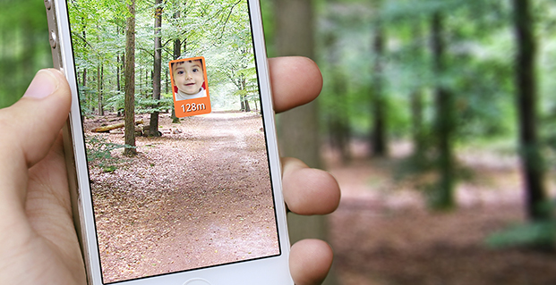
Skip to content

Archives

Avenza Releases MAPublisher 9.4 for Adobe Illustrator

May 9, 2014 - By

Avenza Systems Inc., producers of the PDF Maps app for mobile and geospatial plugins for Adobe Creative Suite, including Geographic Imager for Adobe Photoshop, has released MAPublisher 9.4 for Adobe Illustrator. This latest update includes new  features such as streamlined import, support for additional formats when exporting a document to web tiles, and a new image attribute type to support... read more

This article is tagged with , and posted in Featured Stories, GIS News, GIS Software, Mobile Devices, Technology

Smart Mapping SuperSurv Available on App Store and Google Play

May 9, 2014 - By

Supergeo Technologies, a provider of GIS software and solutions, has launched SuperSurv, a mobile GIS app, on the App Store and Google Play. SuperSurv contains comprehensive GIS data-collection functions. Designed for both iOS and Android powered devices, it integrates with GIS and GPS technologies to provide functions in field survey, such as Map Display, Query, Measure, etc. With SuperSurv, the... read more

Geospatial Corp. Unveils Latest Version of Cloud-Based GeoUnderground

May 9, 2014 - By

Geospatial Corporation has unveiled the company’s newest version of GeoUnderground, its proprietary cloud-based GIS platform custom designed around the Google Maps API and Google Maps Engine. “The economic and social benefit gained through accurately locating, mapping and managing the world’s underground infrastructure assets in a systematic fashion is huge,” said Mark A. Smith, Geospatial CEO. “To accomplish this, Geospatial has... read more

This article is tagged with and posted in GIS News, GIS Software, Mapping, Mobile Devices

SPOT Satellite Devices Mark 3,000 Rescues

May 8, 2014 - By

  SPOT LLC, a wholly owned subsidiary of Globalstar, Inc., says its SPOT products have been used to initiate 3,000 rescues around the world since the technology’s launch in 2007. With more than 200,000 SPOT units in service, that averages to one rescue a day. SPOT delivers affordable and reliable satellite-based connectivity and real-time GPS tracking, completely independent of cellular... read more

This article is tagged with , , and posted in Featured Stories, Latest News, Mobile

TerraStar Offers GNSS Manufacturers Revenue Sharing Opportunities

May 8, 2014 - By

TerraStar is offering GNSS manufacturers revenue sharing opportunities, including the possibility to launch their own precise GNSS augmentation services via endorsed rebranding of TerraStar services as a reseller. According to TerraStar, this will provide an attractive recurring service revenue stream to GNSS manufacturers that was not previously available in the industry. TerraStar is a brand name of TerraStar GNSS Ltd.,... read more

This article is tagged with , and posted in Latest News, Survey

Mother’s Day and Memorial Day Tribute

May 8, 2014 - By

How a Haunting Memory Shaped My GIS Career In the mid ’80s I set up the Navy’s first Geographic Information System (GIS) to accomplish the 1987 base closure study, now called the BRAC (Base Realignment Commission). That first experience with GIS convinced me to pursue GIS as my second career after retiring from the Navy. Fortunately, I was able to... read more

This is posted in GeoIntelligence Insider, Opinions

Sparton Introduces GPS-Assisted Inertial Navigation System

May 6, 2014 - By

Sparton Corporation has announced that Sparton Navigation and Exploration will introduce its GPS/ GNSS Assisted Inertial Navigation System, GAINS-10, at AUVSI Unmanned Systems 2014. GAINS-10 provides accurate inertial navigation in the presence of mechanical shock, transient platform vibrations and extreme magnetic interference. It features high speed, synchronous sampling of all inertial systems combined with high rate coning and sculling compensation... read more

This article is tagged with , , , , and posted in Defense, Latest News

UAV Shipboard Landing with RTK

May 2, 2014 - By

Limited landing area as well as interference due to wind disturbance and wave motion make shipboard landings of unmanned aerial vehicles (UAVs) extremely difficult. Use of UAVs at sea can enhance the efficiency of intelligence gathering and surveillance, and could also increase long-range air-strike capability. read more

This article is tagged with , , , and posted in Defense, Featured Stories, From the Magazine, Transportation, UAV/UGV