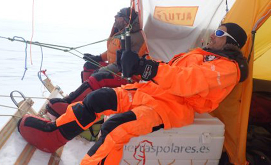
Skip to content

Archives

Durham public works uses Nearmap to manage massive city growth

February 6, 2019 - By

Location content provider Nearmap has partnered with the city of Durham, North Carolina, to help it manage infrastructure projects. The city’s Public Works Department uses Nearmap’s high-resolution imagery to aid in managing all infrastructure data for the city, including the city’s $16 million a year Stormwater Utility Fund. “Having access to imagery back to 2014, we’re able to go back... read more

AMW offers new construction and ag products

February 6, 2019 - By

AMW Machine Control Solutions, a subsidiary of CHC Navigation, has introduced four new solutions for the survey, construction and agriculture markets, all of which run on Android and CHC Navigation GNSS tablet hardware. GRADE I and II Products. GRADE I runs on a CHC Navigation industrial tablet and utilizes an internal meter-accurate GNSS receiver for field workers and supervisors to... read more

UK tests tracking UGVs in military exercise

February 6, 2019 - By

In December 2018 near Salisbury, England, four Milrem Robotics’ and QinetiQ TITAN unmanned ground vehicles (UGVs) were put through three weeks of rigorous tests by British troops during the Army Warfighting Experiment 2018 (AWE18). The goal was to determine how new unmanned technologies can enhance soldier’s survivability and effectiveness on the modern battlefield. The test was conducted in three phases:... read more

Drones survey for geothermal energy in British Columbia

February 6, 2019 - By

Global UAV Technologies Ltd. has completed a drone-based geothermal energy exploration survey for Borealis GeoPower Inc. The survey used UAV-mounted geophysical and thermal imaging sensors over an area in northern British Columbia, Canada. Global UAV subsidiary Pioneer Aerial Surveys collaborated with Hummingbird Drones to collect and analyze high-resolution magnetometer and thermal data over the 2,200-hectare survey area. The survey was... read more

Tesla granted US patent for positioning tech

February 6, 2019 - By

Tesla has developed a technology aimed at providing more accurate positioning for autonomous cars by sharing data between vehicles, according to a U.S. patent application. The patent, “Technologies for vehicle positioning,” was filed in 2017 and made public in December 2018. Solutions include cameras detecting matching locations and using other vehicles in its fleet as “cooperative reference stations” to share... read more

InvenSense provides auto motion sensors for positioning

February 6, 2019 - By

InvenSense (TDK Corporation) has introduced a line of automotive high-accuracy devices: the IAM-20680, IAM-20680HP, IAM-20380 and IAM-20381. According to the company, they are designed to enhance the absolute position of a vehicle in GNSS- and GPS-denied environments. The IAM-20680 is a 6-axis qualified sensor that features 16-bit accelerometers and 16-bit gyroscopes. The IAM-20680HP is a high-performance version of the IAM-20680... read more

PCTEL introduces Coach Wi-Fi/GNSS multi-band antenna for IoT

February 6, 2019 - By

PCTEL Inc. released at DistribuTECH a new dual-band 802.11ac/p MIMO antenna that helps boost data rates and reliability for utility networks, intelligent transportation systems and other industrial IoT (IIoT) applications, according to the company. PCTEL’s Coach 4×4 Wi-Fi/DSRC GNSS multi-band antenna is designed for both mobile and fixed deployments, enabling smart grids, mobile workforce communications, and advanced automation technologies across... read more

Global GNSS launches survey application

February 6, 2019 - By

Global GNSS, a subsidiary of Polosoft Technologies, has launched a new mobile application named GNSS Surveyor, which is designed for the geospatial industry. The application GNSS Surveyor provides location information and quality position data in real-time with sub-meter to centimeter accuracy. It needs to be connected to any external GNSS receiver via Bluetooth. Features of the application include: A one-touch... read more