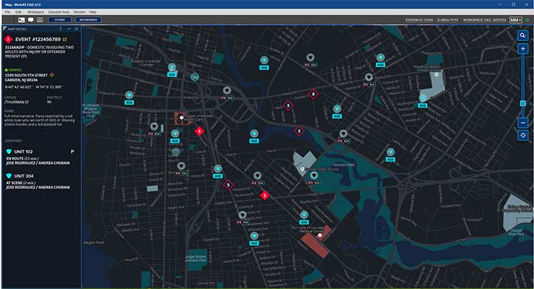
Skip to content

Archives

First development kits available for Septentrio’s mosaic GNSS module

June 20, 2019 - By

Septentrio’s mosaic development kit is now available for testing and integration. Mosaic is Septentrio’s most compact, next-generation, high-precision multi-frequency GPS/GNSS module. The receiver brings precision and reliability of high-end multi-frequency GNSS to mass-market applications, the company said. It is designed to fit into the assembly-line process, which allows mosaic to be favorably priced for high volumes. Its lightweight and low power... read more

This article is tagged with , , , , and posted in Latest News, OEM

K2 will drive GLONASS under 1M

June 20, 2019 - By

New GLONASS-K2 satellites will improve the accuracy of Russia’s satellite navigation system from 3-5 meters to less than 1 meter, said Chief Designer Mikhail Korablyov of the Joint Stock Company GLONASS, operator of the ERA-GLONASS traffic accident emergency response system, at a transport conference in Moscow in late May. Russia plans to launch the first K2 satellite in late 2019... read more

Jammers at dachas add to Russia’s ability to silence GPS

June 19, 2019 - By

A new investigative report by the Russian independent media group “The Project” into luxury dachas owned by high-ranking government officials revealed that most all include GNSS jammers among their amenities. Attempts by the journalists to photograph the dachas from the air using drones were routinely foiled by jamming. Most all nations’ military and security services have equipment that can block... read more

Landviewer’s new change detection tool runs in a browser

June 19, 2019 - By

A major use of remote sensing data is to compare images of an area taken at different times and identify the changes it underwent. With a wealth of long-term satellite imagery in open use, detecting such changes manually would be time-consuming and most likely inaccurate. To address this, EOS Data Analytics has introduced an automated Change Detection tool to its... read more

LandViewer’s change-detection tool runs in a browser

June 19, 2019 - By

A major use of remote sensing data is to compare images of an area taken at different times and identify the changes it underwent. With a wealth of long-term satellite imagery in open use, detecting such changes manually would be time-consuming and most likely inaccurate. To address this, EOS Data Analytics has introduced an automated Change Detection tool to its... read more

Exploring, once again, the brave new world of UAVs

June 19, 2019 - By

Welcome to Part 2 of our coverage of the mammoth AUVSI Xponential 2019 show in Chicago, which drew 8,000 attendees, featured 300+ speakers on its technical program, and furnished a temporary home for more than 800 exhibitors. It was “Everything Unmanned” and a challenge to cover. Last month we looked primarily at new vehicles. This month’s column focuses on sensors,... read more

This article is tagged with , , , , , , , and posted in Opinions, UAV/UGV

ESA focuses on PNT vs GNSS, wants proposals

June 18, 2019 - By

OK, perhaps the headline is a tad misleading. But in addition to its natural preoccupation with Galileo, the European Space Agency (ESA) has begun thinking and talking about PNT as a service and user needs. In 2018, the European Commission issued a memo saying that GNSS alone was not sufficient for many critical and fail-safe operations. ESA is now seriously... read more

This article is tagged with , , , , and posted in GNSS, Latest News

Allystar offers dual-antenna GNSS-aided INS platform

June 18, 2019 - By

The Allystar INS Platform — the company’s latest technology — is a dual-antenna, multi-frequency, multi-GNSS inertial navigation system (INS) that delivers accurate and reliable position, velocity and orientation, the company said. It is designed for a wide range of autonomous vehicle applications under the most demanding conditions. The Allystar INS Platform combines high-grade, six-axis, temperature-calibrated accelerometers and gyroscopes with a... read more