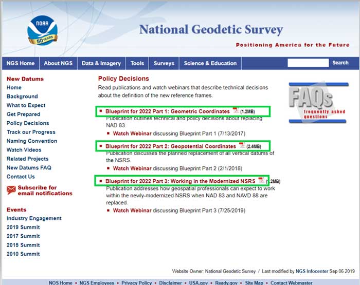
Skip to content

Archives

Lawmakers slam DHS for late, error-filled PNT report

June 9, 2020 - By

Members of Congress were not pleased with the new U.S. Department of Homeland Security (DHS) report on positioning, navigation and timing (PNT), saying the long-delayed report contained numerous errors and failed to address many of the things Congress had required. On the April 8, DHS submitted to Congress the brief, 26-page report on the nation’s PNT requirements. It took more... read more

SimActive releases Correlator3D version 8.5

June 9, 2020 - By

SimActive has launched version 8.5 of its Correlator3D mapping software. According to the company, this new version users to share and visualize projects in the cloud. More specifically, results can be exported to the cloud directly from the software interface, and shareable links are automatically created for online visualization. Version 8.5 also features tools for the calibration and processing of... read more

GMV supplies Spanish MoD with systems of the RPAS Seeker

June 9, 2020 - By

The technology multinational GMV has won a contract under the Spanish Ministry of Defense’s (MoD’s) RAPAZ program for the supply of four Class I Seeker RPASs to be integrated into the intelligence units of the Paratrooper Brigade and the Tercio de Armada de Infantería de Marina (Marine Infantry Protection Force). The contract will provide the armed forces with the most... read more

OGI selects iXblue FOG INS for mobile-mapping lidar

June 9, 2020 - By

Oceanographic & Geophysical Instruments (OGI) has selected iXblue’s Atlans INS to provide robust and uninterrupted data georeferencing to its newly unveiled mobile-mapping lidar solution dedicated to road assessment surveys. A fully integrated mobile mapping solution, this new vehicle-based system integrates advanced systems to provide highly detailed georeferenced survey data to transportation departments throughout the United States. “Highly accurate and reliable georeferencing... read more

TDC and Freeance field apps join with Trimble GIS

June 9, 2020 - By

TDC’s Freeance field applications leverages Trimble GNSS for accurate, streamlined data collection TDC Group has joined Trimble’s GIS (geographic information system) Business Partner Program. As part of the program, TDC has implemented the Trimble Precision SDK (software developer kit) to integrate high-accuracy positioning capabilities in its Freeance mobile software applications running on tablets and smartphones using Trimble GNSS receivers. Freeance... read more

Homeland Security reports on PNT backup, Satelles responds

June 8, 2020 - By

The U.S. Department of Homeland Security (DHS) issued a report on alternative sources of PNT on May 6. It was submitted to U.S. congressional committee leaders on April 8. The Report on Positioning, Navigation and Timing (PNT) Backup and Complementary Capabilities to the Global Positioning System (GPS) highlights the urgent need for GPS backup for critical applications, and it identifies... read more

US senators question FCC on Ligado decision

June 5, 2020 - By

Eight senators sent a letter on June 4 to Federal Communications Commission (FCC) Chair Ajit Pai asking a series of questions about the agency’s decision on Ligado Networks. Signing the letter were Senators Mike Lee, Brian Schatz, Ron Johnson, Edward Markey, Ted Cruz, Mark Warner, John Thune and Chris Coons. All except for Senator Coons serve on the Senate Committee... read more

Orolia delivers its first low SWaP-C miniaturized rubidium oscillator

June 4, 2020 - By

Orolia has introduced a low SWaP-C miniaturized rubidium oscillator, the Spectratime mRO-50, designed to meet the latest commercial, military and aerospace requirements where time stability and power consumption are critical. The oscillator is low SWaP-C — size, weight, power and cost. The Spectratime mRO-50 provides a one-day holdover below 1 µs and a retrace below 1 x 10⁻¹⁰ in a... read more