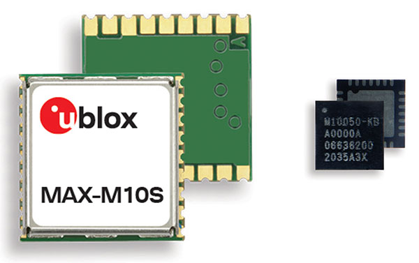
Skip to content

Archives

Spirent Federal to support NASA for GNSS testing

November 17, 2020 - By

NASA has selected Spirent Federal Systems for testing GNSS for lunar exploration. The U.S. Space-Based Positioning, Navigation and Timing (PNT) Policy tasked the NASA Administrator to develop and provide requirements for the use of GPS and its augmentations to support civil space systems. NASA is exploring the viability and enhancement of GPS and GNSS signals in the Space Service Volume... read more

Septentrio debuts mosaic-H heading receiver

November 16, 2020 - By

Septentrio has expanded its GNSS module portfolio with the launch of its mosaic-H heading receiver. According to the company, with dual-antenna capabilities, this surface mount module delivers reliable heading and pitch or heading and roll information on top of centimeter-level positioning. mosaic-H is the new addition to Septentrio’s existing mosaic module family, which already includes RTK and timing modules, as... read more

Swift Navigation precise positioning technology improves GNSS receiver accuracy

November 16, 2020 - By

Swift Navigation announced its precise positioning platform can improve the performance of existing single-frequency GNSS positioning, found on most production vehicles today, from the standard average of 3 meters to lane-level accuracy without changing existing hardware and antenna. According to Swift, these findings are demonstrated during the regular test drives the Swift team conducts to confirm the efficacy of its... read more

Hexagon | NovAtel launches GNSS Resilience and Integrity Technology

November 16, 2020 - By

Hexagon | NovAtel has debuted its GNSS Resilience and Integrity Technology (GRIT), a suite of firmware features enabling situational awareness and interference mitigation tools across applications and environments. Available as a firmware option with NovAtel’s latest 7.08.00 release, GRIT combines NovAtel’s successful Interference Toolkit with the power of spoofing detection. Users can also choose an optional functionality enabling time-tagged snapshots... read more

MGUE Increment 2 contracts awarded to BAE, L3 and Raytheon

November 16, 2020 - By

The United States Space Force’s Space and Missile Systems Center awarded the Military Global Positioning System User Equipment (MGUE) Increment (Inc) 2 Miniature Serial Interface (MSI) with Next-Generation Application Specific Integrated Circuit (ASIC) to BAE Navigation & Sensor System, L3 Technologies (now L3Harris) and Raytheon Technologies. According to the U.S. Space Force, the three MSI contracts are valued at $552... read more

Unmanned survey vessel efficiently maps seabeds

November 15, 2020 - By

Sometimes hands-on data collection just isn’t good enough. In the busy Shizuoka harbor, Weichao Liu of CHC Navigation used the company’s Apache6 marine drone to take a bathymetric survey of a channel in preparation for dredging at a Shizuoka seaport. The Apache6 also collected 3D lidar data above the water’s surface. In May, CHC Navigation launched the 2020 Edition of... read more

Orolia unveils M-code-enabled mobile timing and sync solutions

November 12, 2020 - By

Flexible, resilient military PNT designed for every military environment Orolia, through its Orolia Defense & Security business, has announced the availability of M-code military GPS receivers in its resilient PNT products and solutions, including M-code-enabled mobile mission timing and synchronization platforms. M-code capabilities further enhance Orolia’s Versa mobile PNT platform for rugged, small SWaP-C requirements and Orolia’s flagship SecureSync resilient... read more

How public safety GIS saves us when disaster strikes

November 11, 2020 - By

Tenacity of spirit is one of the great virtues. Supporters of geospatial technology have often had to endure steadfast resolve convincing others of the multi-dimensional value GIS provides. It is a battle best won by seeing and doing rather than by words. Jack Maple proved the value of GIS to public safety in the early 1990s by using it to... read more