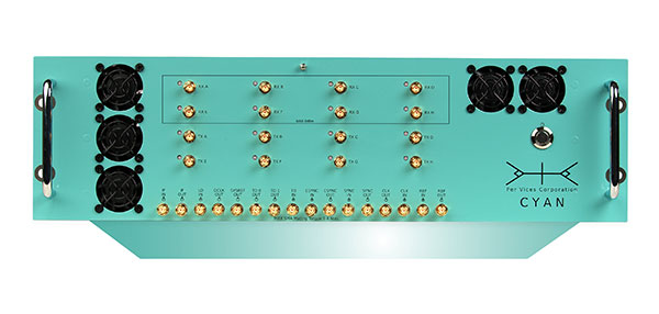
Skip to content

Archives

NV5 Geospatial acquires Geodynamics to expand marine survey offerings

May 18, 2021 - By

Following its March 29 acquisition of Geodynamics LLC, NV5 Geospatial has built a comprehensive suite of solutions for geospatial surveys of deep-water and near-shore environments. Geodynamics will operate as a wholly owned subsidiary of NV5 Global as part of the NV5 Geospatial group. The acquisition brought together complementary, advanced technologies — Geodynamics’ full ocean-depth sonar-based hydrographic and geophysical surveying with... read more

GPS World receives award for COVID-19 coverage

May 18, 2021 - By

GPS World, a business-to-business (B2B) media brand, was honored with a 2021 Azbee Award of Excellence from the American Society of Business Publication Editors (ASBPE). GPS World is published by North Coast Media, based in Cleveland, Ohio. Other NCM brands taking home awards were Pest Management Professional and Golfdom. GPS World received a regional bronze award for its online and... read more

This article is tagged with , , , and posted in COVID-19, Latest News

Javad GNSS launches TRE-3S OEM board, evaluation kit

May 18, 2021 - By

Javad GNSS has launched its TRE-3S GNSS OEM board. It measures 100 x 80 mm, weighs 87 g and tracks 874 channels with all-in-view satellite tracking. At the heart of the board is the company’s new Triumph-3 chip. The board also includes numerous features to protect against interference and improve the signal output. These features include spectrum data output, spoofing... read more

This article is tagged with , , , and posted in Latest News, OEM

BAE Systems receives $325M for M-code GPS modules

May 18, 2021 - By

BAE Systems Inc. has received a $325.5 million contract from the Defense Logistics Agency for advanced military code (M-code) GPS modules that will provide reliable and secure positioning, navigation and timing data with anti-jamming and anti-spoofing capabilities. The modules will help warfighters conduct operations in contested electronic warfare environments. “Our state-of-the-art GPS technology works with the advanced military M-code signal... read more

GeoSLAM tech put to test in Deep Time isolation experiment

May 18, 2021 - By

Geospatial 3D mapping specialist GeoSLAM provided the technology to scan one of Europe’s largest caves as a part of the Deep Time isolation study. For 40 days, 15 participants set up camp in the Lombrives cave in southwestern France with no clocks or sunlight, and zero contact with the outside world. Conducted by the Human Adaptation Institute, the experiment aimed... read more

Maxtena offers active multi-frequency antenna

May 17, 2021 - By

The M9708CWT-UFL from Maxtena is an active multi-frequency, high-accuracy, GNSS antenna for the L1/L2/L5 GPS, Galileo, Beidou and GLONASS bands. The antenna is designed for applications requiring greater accuracy than L1-only antennas can provide. The antenna’s excellent radiation pattern, exceptional out-of-band rejection, minimal group delay variation, and low noise figure ensures optimal performance of GNSS systems, according to Maxtena. The... read more

This article is tagged with , , , , and posted in Latest News, OEM

Orolia selected to deliver next-gen Galileo GNSS simulator

May 17, 2021 - By

The European Commission and the European Space Agency (ESA) have selected Orolia to provide the core GNSS simulation engine for the Galileo Second Generation (G2G) RF Constellation Simulator (G2G RFCS). While the first launched Galileo satellites are reaching the end of their theoretical operational life, the G2G initiative includes the preparation of a future generation of Galileo global infrastructure, from... read more

Earth Archive project aims to create digital twin of entire planet

May 14, 2021 - By

The Earth Archive Initiative is an unprecedented scientific effort to create a digital twin of the entire surface of the Earth – and everything on it. By scanning the planet’s land surface with very high-resolution lidar, the Earth Archive will create a true three-dimensional digital twin of our world — an open source, digital record of the Earth that will... read more