Listen to this content
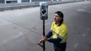
Hexagon | NovAtel has entered into a Memorandum of Understanding (MOU) with GPR, Inc. to integrate GPR’s WaveSense ground-penetrating radar sensors into NovAtel’s SPAN GNSS/INS solution. This collaboration aims to explore the integration of NovAtel’s SPAN system with GPR’s subsurface mapping technology, enhancing positioning solutions for applications requiring high reliability and centimeter-level accuracy, such as autonomous systems, mining and other mission-critical operations.
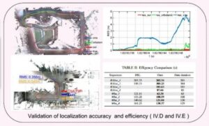
NovAtel’s SPAN GNSS+INS technology has historically provided reliable position, velocity and attitude (PVA) data by combining GNSS signals with IMU data. This approach ensures continuous accuracy during short GNSS interruptions caused by environmental factors like foliage or buildings. By incorporating WaveSense’s ground-penetrating radar as an additional input, the system can maintain accurate PVA solutions even during extended GNSS outages due to obstructions, signal interference, or jamming. This integration is particularly beneficial in GNSS-denied environments or areas lacking clear surface structures.
WaveSense technology operates by scanning up to 10 ft below the ground to map unique subterranean features. These stable underground patterns serve as a reliable reference for navigation, unaffected by adverse weather conditions such as snow, rain or fog. The combination of SPAN and WaveSense technologies is expected to significantly enhance navigation accuracy and reliability in challenging environments, according to the company.
Under the terms of the MOU, NovAtel and GPR will collaborate on specific use cases to demonstrate the combined capabilities of SPAN and WaveSense in demanding applications. Following these demonstrations, the partnership may advance toward a full product definition and supply agreement, according to the companies.