Listen to this content
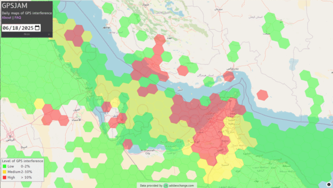
GNSS jamming is causing confusion for ships traveling through the Strait of Hormuz, reports gCaptain. The regional threat levels are labeled “significant” because of air strikes between Iran and Israel, according to the Joint Maritime Information Center (JMIC). Maritime threat levels are marked as “elevated”.
The JMIC highlighted GNSS jamming problems around the Port of Bandar Abbas and throughout the Strait of Hormuz and Persian Gulf regions. Nevertheless, commercial shipping traffic has continued at normal rates.
Naivgational error is considered the cause of a collision June 17 between two tankers in the Gulf of Oman. The Very Large Crude Carrier (VLCC) Front Eagle, with 2 million barrels of Iraqi crude bound for China, hit the Suezmax tanker Adalynn 15 nautical miles off Fujairah. There was fire on both ships, but no injuries. The Front Eagle appeared to be onshore in Iran days before the collision.
Nearly 1,000 ships in the Gulf have been affected by mass interference since the start of the Iran-Israel conflict on June 12, according to shipping analysis firm Windward. Recent tracking data has shown unusual positioning errors, with vessels appearing to be in impossible locations.