No audio available for this content.
By Art Kalinski, GISP
Last week I attended the ION GNSS+ Conference (Institute of Navigation / Global Navigation Satellite Systems) in Nashville, touted as the largest GNSS conference in the world. Although Geospatial Solutions is closely aligned with GPS World, my focus is on GIS, and like most GIS people, we look at GPS devices as data collection tools and most of us don’t get heavily involved with the workings of the equipment or GPS community.
Since I only live two hours away from Nashville, my editor, Alan Cameron, invited me to attend so I could meet the GPS World staff and peek over the wall into the GPS community. It was time well spent, since I was exposed to the ongoing evolution and problems being addressed by the GPS community, which seems to have a higher percentage of Ph.D.s than any other conference I’ve attended. There was a lot of hardware and software outside my realm of experience, so some of my observations may be simplistic or old news to some of you. Please bear with me as I share topics that I believe may be of interest to the GIS community.

GPS Basics and History
For starters, GPS is just a modern tool to do global navigation, not much different from when I was doing celestial navigation on a Navy destroyer in the ’70s and ’80s. The concept is fairly simple, although the execution is not.
Every star in the sky is fixed in space with an observer on earth either at the nadir point where the star is directly overhead at 90 degrees or most likely somewhere between 90 degrees and the horizon, 0 degrees. A sextant is used to measure that angle, and all possible points at that angle describe a unique circle on the Earth where that measurement can exist. Intersection of two other star circles can then locate a unique point on the earth. This sounds simple in theory, but the actual process is not, since the Earth is constantly rotating, wobbling and moving through its annual orbit. Additionally, cloud cover can obscure the stars, and rough weather can make precision observations all but impossible. Then, after shooting the stars, over an hour of work was required looking up data in celestial tables and doing tedious computations to get each line of position.

Early electronic navigation systems such as Omega and Loran C helped made some navigation a bit easier. They used time delay and phase shifting between radio transmitters to create hyperbolic lines of position between two transmitters. Three transmitters produced two sets of lines, and the intersection was your position. Both celestial and early electronic navigation were not very accurate and not particularly easy to use. Both were phased out in favor of GPS, which sort of combines the concept of celestial with electronic navigation.
GPS even uses the term a “constellation” of satellites. The satellites provide very exact position information to GPS receivers, which calculate the observer’s position similar to celestial fix. Additionally, accurate and precisely measured time is so important that scientists actually take into account the theory of relativity and dilation of time caused by the very fast travel of GPS satellites to have system accuracy that is adequate.
New Players
GPS was developed in the ’60s and ’70s by the U.S. military, but opened to civil use by Ronald Reagan after the shooting down of KAL flight 007 by the Soviet Union. They thought the 747 was spying, but in reality the inaccurate navigation systems erroneously put the civilian airliner into Soviet airspace. In the late ’90s, the U.S. Navy moved to GPS and away from traditional celestial and land-based electronic navigation because it was so tedious and prone to errors. However, there are second thoughts about complete reliance on GPS. The Naval Academy and Navy navigation school currently teach a shortened celestial course using a sextant and specialized calculator that performs the complex and tedious calculations.
Although GPS was developed by the U.S. military, there are other players — the Russian GLONASS system operational in 1995, the more recent European Galileo, Chinese Compass (now called BeiDou,) and soon India’s IRNSS and Japan’s proposed QZSS. What that means for us users is cheaper systems with greater accuracy, redundancy and better coverage.
RTK (Real Time Kinematics)
Several years ago, RTK satellite navigation was developed to enhance the precision of GNSS, usable with GPS, GLONASS and/or Galileo. Rather than relying only on the GNSS position information, the RTK system also uses phase measurements of the GNSS carrier signals and combines that with a single or network of ground reference stations, similar to Differential GPS, which provides real-time corrections with centimeter-level accuracy. RTK hardware is becoming ubiquitous, and prices are dropping dramatically. A new entry, Piksi by Swift Navigation, is promising a complete RTK system suitable for UAVs for less than $900.
Geodesy and MSL
I never had a strong interest in geodesy, but talking to Kevin Kelly, ESRI’s geodesist, I was surprised to learn that something as basic as mean sea level is being challenged by GPS measurements. There has been a concern for years that the universally used datum has numerous intrinsic errors (See an ESRI paper for more information). The errors are caused by local conditions such as variations in the Earth’s gravitational field, sea currents, air-pressure variations, temperature and salinity variations, etc. Scientists are looking to move from MSL to a GPS-generated gravity model to serve as a more accurate datum.
Indoor Location Technology
I’ve had a long-term interest in indoor location technology after learning how critical the need was in tracking first responders inside buildings. Two years ago, I wrote about a promising device by NAViSEER that combined GPS with a new microchip-based IMU (inertial measurement unit). The IMU contained three accelerometers and three gyroscopes capable of measuring inertial acceleration and movement in three axes. Regrettably, drift of the IMUs have limited their usefulness.
Another approach is reading of RFID tags, but these have to be installed and mapped in advance.
A technology I was able to test was a Time Domain ranging radio. The low-cost device has 2-mm accuracy and is being used in many robotic plant operations. Although very accurate, it is a line-of-sight device. Bottom line: There still is no overarching solution to indoor tracking.
GNSS Problems and eLoran
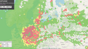
There were several presentations on how vulnerable satellites were to jamming, spoofing, cyber attacks and even severe solar storms. Several presenters discussed defensive strategies and equipment. Other presentations discussed current efforts to reestablish Loran as an alternative to GNSS. A new Loran system, eLoran, seems to have strong following in some foreign countries, with serious ongoing discussions with U.S. users. Enhanced Loran (eLoran) is built with modern transmission and receiver design that increase the accuracy and usefulness of traditional Loran, with reported accuracy as good as ± 8 meters. Not great, but a good alternative if GNSS goes down.
Other Non-Satellite Positioning Systems
A keynote presentation that created a stir with the GNSS crowd was given by Nunzio Gambale, founder of the Australian firm Locata. His thesis was that satellites have run their course and are potentially vulnerable to numerous hazards and limitations. You can view his keynote speech video.
His firm invented a radio-location technology that gives precise positioning in environments where GPS is either marginal or unavailable, or to use during GNSS outage. Locata also offers a precision indoor navigation solution using a patented VRay antenna technology that defeats errors in high-multipath environments.

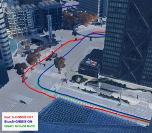
The basic system consists of a local network of terrestrially based transceivers that provide well-synchronized signals that operate in combination with standard GPS or totally independent of GPS. The system has the ability to replicate a GPS satellite constellation locally — on the ground. He envisions a cell-phone-tower-like system that could back up GNSS. The system is especially useful in mines, construction sites, warehouses, airports, strategic infrastructure, and heavy urban canyon cities that suffer from multipath interference. A Leica/Locata system is being used by Newmont in open-pit gold mining with better than 10-cm accuracy. The Air Force installed Locata at the expansive White Sands Missile Range as a reference system that can provide truth reference data during GPS vulnerability testing (jamming experiments). The Locata system delivers <18-cm 3D positioning over 2,500 square miles.
A Geospatial Vendor
There was one geospatial vendor in the Expo, so my attention was caught. Consolidated Resource Imaging, LLC (CRI) was demonstrating its LodeStar real-time camera system. It’s a persistent wide area airborne surveillance system similar to Gorgon Stare that is touted as offering smaller size and lower weight, power and price. Dr. Gregg Wildes, CRI’s senior program manager, demonstrated examples of Wide Area Motion Imagery (WAMI) with their tracking and analysis tools.


The system has the ability to track and back track vehicles to their origins within the motion imagery footprint. The geo-referencing is accomplished by mounting a high-accuracy CRI NAV 100 GPS/IMU navigation system to the camera plane. This approach is similar to the system used by Pictometry to capture geo-referenced oblique imagery. The actively stabilized sensor system provides improved resolution and accurately geo-referenced imagery exportable to Google Earth and other WMS GIS applications.
Conclusions
My key takeaway was that, like Moore’s Law, GNSS equipment continues to get faster, cheaper and more accurate while other location technologies grow in use and capability. My one nagging concern is the potential vulnerability of satellite systems. We’ve become extremely dependent on GNSS and I don’t need yet one more thing to worry about.