Skip to content

UAV/UGV

Credit: MySky ECO

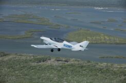
MySky ECO and Airwayz to develop long-range UAV system

July 30, 2025

This article is tagged with , , , and posted in Latest News, UAS/UAV, UAV/UGV
ASPA 135 ground setup for HSI and GNSS RTK data collection. (a) Precise positioning of a Konova slider attached to two tripods on rocks, to minimize disturbance of moss and lichen. (b) GNSS RTK point collection with a Trimble R10 antenna on a fixed marker with known coordinates. (Credit: QUT)

Drones detect moss beds and changes to Antarctica climate

July 28, 2025

Credit: Swift Navigation

Swift Navigation secures funding for its Skylark cm positioning service

July 28, 2025

This article is tagged with , and posted in Latest News, OEM, Transportation, UAV/UGV
For the first time, researchers at Institute of Industrial Science, The University of Tokyo, quickly and efficiently measure the seafloor down to the centimeter-level using a UAV. (Credit: Institute of Industrial Science, the University of Tokyo)

Advancing earthquake prediction with a UAV

July 24, 2025

This article is tagged with , , and posted in Latest News, Space & Earth, UAS/UAV, UAV/UGV
Photo: gremlin / E+ / Getty Images

AI maps: The digital infrastructure driving autonomous systems

July 21, 2025

Credit: Airbus

SandboxAQ and Acubed advance magnetic navigation 

July 16, 2025

Alpha A900 approaches for deck landing. (Credit: Alpha)

Helicopter and space UAVs pave the way for autonomous systems

July 16, 2025

GloTEC, a real-time global Total Electron Content (TEC) map from NOAA’s Space Weather Prediction Center (SWPC), was released in February 2025. GloTEC assimilates both ground- and space-based observations to provide real-time global ionospheric corrections without relying on error-prone linear combinations. (Credit: NOAA)

Nowcasting the ionosphere: Evaluating GloTEC for real-time GNSS corrections

July 14, 2025