
Septentrio adds onocoy to Agnostic Corrections Partner Program
July 14, 2025
Septentrio, part of Hexagon, has added the onocoy GNSS correction service to its Agnostic Corrections Partner Program.
Read More
Septentrio, part of Hexagon, has added the onocoy GNSS correction service to its Agnostic Corrections Partner Program.
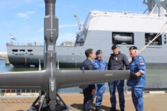
The Netherlands Ministry of Defence has procured eight V-BAT unmanned aircraft systems from Shield AI to enhance maritime […]

Precise Point Positioning (PPP) has long held promise as a standalone, high-accuracy positioning technique, but its slow convergence […]

SatLab has introduced the HydroBoat 1200MB, a compact USV engineered for 3D hydrographic surveying in inland and nearshore waters.
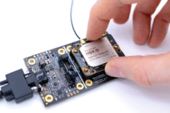
MicroStrain by HBK has launched the 3DM-CV7-GNSS/INS, an ultra-compact, tactical-grade inertial navigation system (INS) designed for seamless integration […]

Ukraine has received its first Shark ultralight aircraft with electronic warfare (EW) capabilities from the Czech-Slovak company Shark.Aero.

In the mission-critical world of aerospace and defense, where reliability and resilience can mean the difference between success and failure, precision timing is essential.


Follow Us