India continues to make significant progress in developing indigenous unmanned aerial vehicles, loitering munitions and autonomous systems.
The National Association of State Aviation Officials provides opportunities for those engaged in aviation and unmanned aerial vehicles. […]

For anyone out there who has ever worked through a formal process of equipment development for subsequent FAA/military or other national certification, you would likely appreciate the significance of a UAV approval milestone.
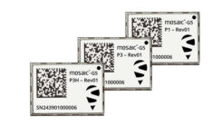
Septentrio, part of Hexagon, has introduced the mosaic-G5 series, expanding its line of compact GNSS receiver modules.

Vatn Systems launched its new S12 AUV-torpedo product line. The company also opened a new manufacturing facility in Rhode Island.
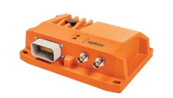
Read a roundup of recent products in the GNSS and inertial positioning industry from the May 2025 issue of GPS World magazine.


Follow Us