
Launchpad: New surveying and mapping products, MEMS sensors and more
December 16, 2024
A roundup of recent products in the GNSS and inertial positioning industry from the December 2024 issue of GPS World magazine.
Read More
A roundup of recent products in the GNSS and inertial positioning industry from the December 2024 issue of GPS World magazine.
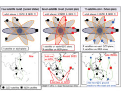
Japan’s Cabinet Office (CAO) is currently developing the Quasi-Zenith Satellite System (QZSS) seven-satellite constellation (7SV-const.)
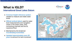
David Zilkoski provides updates about the vertical datums that the National Oceanic and Atmospheric Administration (NOAA) is working on.
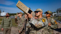
The U.S. Department of Defense (DOD) has unveiled a comprehensive classified strategy for countering unmanned systems.

Automotive navigation is highly connected and capable of dynamically using high-resolution map information and vehicle and environmental data from the cloud.

Notre Dame Cathedral in Paris has reopened its doors five years after the devastating fire, showcasing its restored interior after extensive rebuilding work.
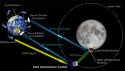
ArkEdge Space has been selected by JAXA under its Space Strategy Fund to lead the development of advanced lunar navigation technology.

This is a challenging time for coral reefs. Although they cover less than 0.1% of the ocean floor, coral reefs support 25% of all marine creatures.


Follow Us