3D cm achieved with UAV/van mapping system MapKITE
February 12, 2019
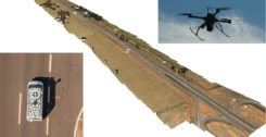
Kinematic Ground Control point for UAV photogrammetry: A dynamic duo of UAV and mobile van combine to deliver the […]
Read More
Kinematic Ground Control point for UAV photogrammetry: A dynamic duo of UAV and mobile van combine to deliver the […]

A new map method opens up parking continuous-environment mapping for enhanced low-cost urban navigation. Collectively recorded context data by […]

New developments in antenna technology empower the final positioning solution with better accuracy and reliability. Leading experts discuss […]

Space Flight Laboratory (SFL) has launched three formation-flying HawkEye 360 Pathfinder 15-kilogram, 20 x 27 x 44-centimeter microsatellites […]

Are drones (UAVs) a disruptive or constructive technology for high-precision mapping that yields practical, actionable results for the end […]

Planet (formerly Planet Labs) has put about 300 satellites into space, in charge of photographing the entire land […]

Industry experts share how GNSS can be used for precision agriculture. EUROPEAN SATELLITE SERVICES PROVIDER (ESSP) Juan Vazquez […]

By Juan Vázquez, Elisabet Lacarra, Jorge Morán and Miguel A. Sánchez, ESSP SAS, and Julian Rioja and Jimmy […]


Follow Us