Correcting the census: Household sizes in Maptitude 2019
April 17, 2019
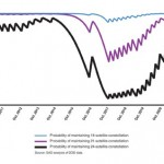
Household size distributions are critical inputs to many business analyses, but may not be correctly derived from U.S. […]
Read More
Household size distributions are critical inputs to many business analyses, but may not be correctly derived from U.S. […]
SimActive Inc., a developer of photogrammetry software, announced that Correlator3D is being used for mapping projects in Brittany, […]
Global Mapper Mobile is now available to U.S. government agencies through the Innovative GEOINT Application Provider Program (IGAPP). […]
The Trimble TDC150 handheld is a new field computer designed for GIS data collection, inspection and management activities. The […]
Written by William Tewelow, GISP and Co-written by Jon Gustafson, GISP Significant focus on infrastructure asset delivery and […]

Airbus Defence and Space and The Climate Corporation, a subsidiary of Bayer, have announced a global agreement to […]
The Copernicus Masters competition awards applications and solutions that use Copernicus data to tackle important challenges. Submissions for […]
The WingtraOne vertical take-off and landing (VTOL) fixed-wing mapping drone now carries the RedEdge-MX multispectral sensor for vegetation […]


Follow Us