Skip to content

Innovation

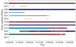
Figure 1. Satellite tracking and carrier-phase anomaly summary during the observation time-span. These data were collected in a dense urban environment in both static and kinematic mode. The superimposed red-points show epochs where carrier-phase observables are either missing or contaminated with cycle slips, loss of locks, and/or other measurement anomalies.

Innovation: Doppler-Aided Positioning

May 1, 2011

This article is tagged with , , and posted in From the Magazine, Innovation, OEM
Source: Richard Langley

Innovation: GLONASS

April 1, 2011

This article is tagged with and posted in From the Magazine, GNSS, Innovation
Source: Richard Langley

Innovation: Realistic Randomization

March 1, 2011

This article is tagged with , , and posted in Innovation, OEM
Courtesy of Richard and Marg Langley.

Innovation: GNSS and the Ionosphere

February 1, 2011

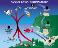
FIGURE 1. Overall concept of search and rescue system. (Image: Cospas-Sarsat)

Innovation: The Distress Alerting Satellite System

January 1, 2011

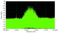
Figure 2. GPS is visible in the spectrum only if a narrow resolution bandwidth is used. This spectrum was obtained with a center frequency of 1575.42 MHz, a frequency span of 4 MHz, a resolution bandwidth of 10 Hz, root-mean-square averaging with 20 averages, and a reference level of 250 dBm.

Innovation: Record, Replay, Rewind

October 1, 2010

This article is tagged with , , and posted in From the Magazine, Innovation, OEM
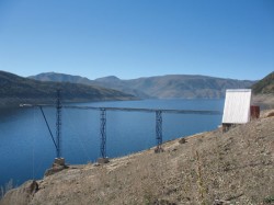
Figure 4. The Oceanpal installation at Lake Laja, Chile.

Innovation: Friendly Reflections

September 1, 2010

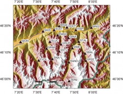
Figure 3. The 21 GPS stations in the project area in the mountainous canton of Valais (see also Figure 2) used during the measurement campaign in July 2005. The stations’ altitudes vary between 527 meters (SION) and 3119 meters (ZER2).

Innovation: Better Weather Prediction Using GPS

July 1, 2010

This article is tagged with , , , and posted in From the Magazine, Innovation