
Woolpert to collect lidar data for USGS
July 2, 2024
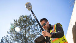
The U.S. Geological Survey (USGS) has commissioned Woolpert to collect Quality Level 1 lidar data and conduct ground control surveys throughout Southern California.
Read More
The U.S. Geological Survey (USGS) has commissioned Woolpert to collect Quality Level 1 lidar data and conduct ground control surveys throughout Southern California.

uAvionix has successfully installed and approved its surface situational awareness systems at two major U.S. airports: Indianapolis International Airport (IND) and Austin-Bergstrom International Airport (AUS).

GPS World met with Senior Vice President for Trimble’s Owner and Public Sector, Cyndee Hoagland, to talk Trimble’s new product suite, how GIS plays a pivotal role in the asset management lifecycle and more.
Trimble has introduced the Trimble R980 GNSS system, featuring communication capabilities to support uninterrupted field operations.

“Seen & Heard” is a monthly feature of GPS World magazine, traveling the world to capture interesting and unusual news stories involving the GNSS/PNT industry.

SandboxAQ has released AQNav, designed for navigation across air, land and sea when GPS signals are jammed or not available.
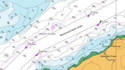
Teledyne Geospatial has launched the CARIS AutoChart, a nautical chart production solution.

HERE Technologies has launched its Fleet Optimization software package, designed to enhance the efficiency and scalability of fleet management operations.


Follow Us