
Scientific Systems advances navigation software
March 7, 2024
Scientific Systems has released upgrades for ImageNav, an image-based navigation software designed for GPS-denied or compromised environments.
Read More
Scientific Systems has released upgrades for ImageNav, an image-based navigation software designed for GPS-denied or compromised environments.

The GEODNET Foundation — the organization governing the blockchain-based global navigation network GEODNET — has completed a $3.5 million seed funding round.
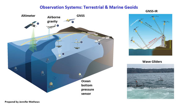
The NOAA has awarded Scripps Institution of Oceanography (SIO) and The Ohio State University (OSU) grants to develop models to address what NGS denotes as the Intra-Frame Deformation Model (IFDM).

Iridium Communications, a satellite network operator, will acquire Satelles for $115 million. Satelles is a provider of secure […]

The European Organization for the Safety of Air Navigation (EuroControl) has awarded GMV a contract for the evolution of AUGUR, a free service for pilots, airspace users and air navigation service providers.

Should GPS have a satellite-based high-accuracy service, like Galileo’s and BeiDou’s? What would it take to build it?
Read Richard Langley’s introduction to this article: “Innovation Insights: What is a CubeSat?” Bobcat-1 was a three-unit CubeSat […]

Topcon Positioning Systems has expanded its support for the Get Kids into Survey (GKiS) project, now serving as the exclusive sponsor of the Global Brand Ambassador Hub.


Follow Us