Teledyne introduces nautical chart production solution
June 27, 2024
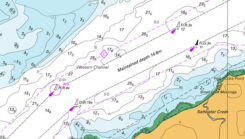
Teledyne Geospatial has launched the CARIS AutoChart, a nautical chart production solution.
Read More
Teledyne Geospatial has launched the CARIS AutoChart, a nautical chart production solution.

HERE Technologies has launched its Fleet Optimization software package, designed to enhance the efficiency and scalability of fleet management operations.

The Global Earth Observation Decentralized Network (GEODNET) Foundation has entered new distribution and OEM agreements with AllyNav, Bad Elf, bynav, Sensori Robotics and Unmanned Life.
Tualcom has released TRNAV, a terrestrial navigation solution designed to operate with or without GNSS signals.

GNSS researchers presented hundreds of papers at the 2023 Institute of Navigation (ION) GNSS+ conference, which took place Sept. 11-15, 2023, in Denver, Colorado, and virtually. The following four papers focused on ways to navigate urban environments.

GPR Ground Positioning Radar, a producer of ground-penetrating radar technology for autonomous vehicle localization, has entered a strategic collaboration with Rheinmetall Provectus, a provider of autonomous navigation solutions.

Iridium Communications has expanded the commercial availability of its Satellite Time and Location (STL) service to parts of Europe and the Asia Pacific.


Follow Us