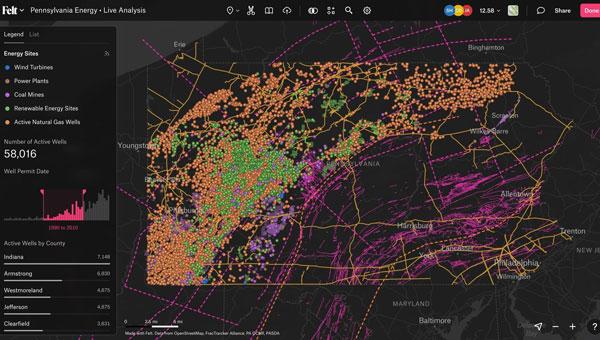
Skip to content

Mapping

Figure 1: The side-facing horn antenna in its radome enclosure (left panel) and the hardware block diagram of the data collection system (right panel). (All figures provided by the authors)

Using GNSS Phase Reflectometry on Maui’s Haleakalā

November 17, 2023

1
Image: Trimble

Trimble partners with HALO Trust for landmine clearance in Ukraine

November 16, 2023

This article is tagged with , , , , and posted in Latest News, Mapping, Survey
2
Skydio X10 UAV. (Image: Skydio)

Skydio, Trimble integrate GNSS technologies for construction, utilities, transportation agencies

November 15, 2023

This article is tagged with , and posted in Latest News, Mapping, Survey, Transportation, UAV/UGV
3
Photo:

Launchpad: New GNSS receivers, antennas and PPK software

November 13, 2023

4
this Kalmar container handler has a Septentrio high-accuracy GNSS/INS receiver and an inertial system, which operate in challenging environments of low satellite visibility. (Image: Kalmar)

GNSS solutions for challenging environments

November 6, 2023

5
Image: FrankRamspott/E+/Getty Images

Mapping marvel: Mapping Earth’s wildfires

November 4, 2023

6
Photo: payamona / iStock / Getty Images Plus / Getty Images

Federal agencies addressing the geodesy crisis

November 1, 2023

7
Image: YiBaoTY/iStock/Getty Images Plus/Getty Images

Seen & heard: Catching crime and tracking songbirds

October 31, 2023

This article is tagged with , , , and posted in Featured Stories, From the Magazine, Latest News, Mapping, UAV/UGV
8