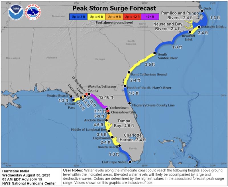
Skip to content

Mapping

An Ellingson Companies surveyor works on an underground utility line. (Image: Ellingson Companies)

Minnesota company develops new system for mapping underground utilities

February 22, 2023

TrueView 535. (Image: GeoCue)

GeoCue adds to its UAV/lidar imagery systems

February 15, 2023

This article is tagged with , , and posted in Latest News, Mapping, Survey, UAV/UGV
Image: Hexagon

Hexagon releases platform for defense mobile apps

February 13, 2023

Image: Golden Software

Golden Software enhances surface mapping package

February 13, 2023

This article is tagged with , , and posted in Latest News, Mapping
Photo:

Linux Foundation forms Overture Maps Foundation

February 9, 2023

This article is tagged with , , and posted in From the Magazine, Mapping
Image: OxTS

How to select an INS for mobile mapping

February 9, 2023

The impact of the earthquakes was significant and ranks in the red for economic losses and orange for fatalities, according to the U.S. Geological Survey (USGS). (Image: UNOSAT)

Emergency satellite mapping of Turkiye and Syria activated

February 9, 2023

Parts of the historic Gaziantep Castle collapsed, as it lies close to epicenter of the magnitude 7.8 earthquake. (Image: JudyDillon/ iStock / Getty Images Plus/Getty Images)

Earthquake damages cities in Turkiye and Syria

February 6, 2023