
Leica Ultra locator finds underground utility lines
February 16, 2016
Leica Geosystems has released the Leica Ultra underground service locating system for site engineers and underground utility specialists who […]
Read More
Leica Geosystems has released the Leica Ultra underground service locating system for site engineers and underground utility specialists who […]
Topcon Positioning Group has added the FC-5000 to its line of data controllers for construction and surveying professionals. The […]
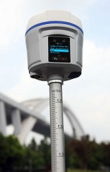
The i80 GNSS receiver computes a true triple-frequency real-time kinematic (RTK) tilted pole solution using all four worldwide and multiple regional constellations, providing a future-proof sub-centimeter RTK solution to surveyors and contractors.
Topcon Positioning Group has released a new excavator system with local positioning system (LPS) capabilities. The X-53i LPS […]
UAV company DJI is offering its first tuned propulsion system designed for all-weather use in industrial applications and […]
Topcon Positioning Group has released the latest addition to its ES total station series, the ES-50. Featuring advanced reflectorless […]
Antenova Ltd., manufacturer of antennas and RF antenna modules for machine-to-machine (M2M) and the Internet of Things, is […]
Windows 10 and a new large display are key features of Juniper Systems’ latest tablet, Mesa 2 Rugged […]


Follow Us