February 16, 2026 Pakistan demonstrates advanced Pak-SBAS navigation system in desert rally By Tracy Cozzens
February 10, 2026 Divirod, OKI completes advanced GNSS-R terrain monitoring project in Fukuoka Prefecture By Tracy Cozzens
February 9, 2026 Aptella offers free RTK positioning for bushfire and flood recovery volunteers By Tracy Cozzens
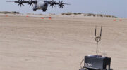
February 2, 2026 Cleared for the dirt: How robotic rovers are revolutionizing military runway assessment By Pieterjan De Meulemeester, Alain Muls, Jarno Van Audenhoven, and Pascal De Kimpe
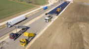
January 28, 2026 European PAVE-SCAN project aims to increase transport efficiency, safety By Tracy Cozzens
January 20, 2026 CHC Navigation releases Apache 6 USV for high-resolution marine surveying By Tracy Cozzens