
Lane-level positioning with low-cost map-aided GNSS/MEMS IMU integration
May 7, 2018
A lane-keeping system uses a sensor-fusion engine integrating GPS and an IMU with a two-stage map-matching algorithm. The system […]
Read More
A lane-keeping system uses a sensor-fusion engine integrating GPS and an IMU with a two-stage map-matching algorithm. The system […]

The GPS World and Geospatial Solutions staff reported live from the Association for Unmanned Vehicle Systems International’s (AUVSI’s) […]

GNSS receiver manufacturer Septentrio has been selected to supply its high-precision AsteRx-m2 GNSS OEM receiver module and PPK […]

Five organizations that flew drones on critical, life-saving missions are winners of the inaugural XCELLENCE Humanitarian Award by […]

Harxon showcased high-precision positioning GNSS antennas and its latest wireless data-transmission technologies for UAV applications at AUVSI Xponential, which […]
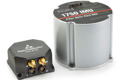
VectorNav’s Tactical Series line of inertial navigation systems now supports KVH’s high-performance fiber optic gyro-based 1750 IMU and […]

NovAtel has introduced several new precision positioning solutions for space-constrained applications. With enhanced positioning accuracy in a compact […]

For several months, Talen-X engineers have been working with the proper channels to develop MNSA (Modernized Navstar Security […]


Follow Us