Lidar and UAV reveal Mayan ‘megalopolis’ below Guatemalan jungle
February 20, 2018
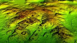
Lidar and UAV technology has revealed hundreds of previously unknown Mayan ruins in the Guatemalan rainforest. In what is […]
Read More
Lidar and UAV technology has revealed hundreds of previously unknown Mayan ruins in the Guatemalan rainforest. In what is […]

As part of a framework agreement with Dubai Petroleum, Cyberhawk was appointed to inspect more than 350 risers […]

China continues to update the BeiDou navigation satellite system. On Feb. 12, two more navigation and positioning satellites […]

While in orbit, the Deep Space Atomic Clock (DSAC) mission will use the navigation signals from GPS coupled […]

More satellites, more constellations, more multi-frequency receivers — they all drive greater achievable accuracy. But they also raise […]

News from the European Space Agency The next generation of Europe’s satellite navigation overlay service, EGNOS, will combine […]
There was plenty for a philosophy major to sink his teeth into at ION’s January workshop on Cognizant […]
EGNOS V3 will offer improved and secure Civil Aviation Safety of Life services for the next decade over […]


Follow Us