
Spain’s PLD Space to develop GNSS-IMU for reusable space vehicles
September 19, 2025
PLD Space, based in Elche, Spain, has been selected by the European Space Research and Technology Centre (ESTEC) […]
Read More
PLD Space, based in Elche, Spain, has been selected by the European Space Research and Technology Centre (ESTEC) […]

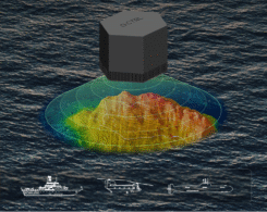
A massive earthquake and subsequent tsunami off Russia in late July tested an experimental detection system that had deployed a critical component just the day before.

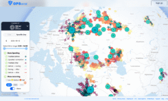
GNSS jamming and spoofing pose a significant threat to global security, as satellite-based navigation and timing systems are utilized in various application fields.
Dimetor and SkAI Data Services are announcing a strategic partnership to increase global airspace security.

The European Space Agency has confirmed plans to launch the first two satellites in its low-Earth orbit (LEO) positioning navigation and timing (PNT) constellation in the second half of December 2025.
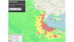
A plane carrying the European Commission President Ursula von der Leyen was targeted by GPS jamming.

Recent eVTOL innovations, FAA-certified autonomous flight systems and UAV testbeds are reshaping urban air mobility and cargo automation.


Follow Us