
New Speakers Announced for Thursday’s Street Smart Webinar
July 14, 2015
Three new speakers have been announced for Thursday’s GPS World Market Insights Webinar. The webinar, “Street Smart: City Modeling […]
Read More
Three new speakers have been announced for Thursday’s GPS World Market Insights Webinar. The webinar, “Street Smart: City Modeling […]

Juniper Systems is exhibiting its sub-meter GPS solution using Esri ArcPad, Effigis’ EZSurv Post-Processing software, and its ultra-rugged handheld computers — […]
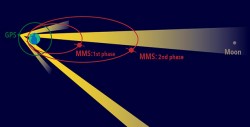
Results are now in for NASA’s Magnetospheric Multiscale mission, which launched on March 12. Not only has the MMS Navigator system exceeded all of the team’s expectations, it has set the record for the highest GPS use in space.
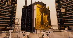
United Launch Alliance crews on July 7 placed the next GPS satellite on top of an Atlas V rocket for […]
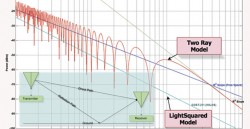
The GPS Innovation Alliance has responded to recent media reports on LightSquared’s position regarding the testing of the compatibility of […]

“Time waits for no one,” Mick Jagger lamented in song when he turned 30. But tonight, on the […]

Hover technology has long been depicted in movies like Star Wars and Back to the Future. Now the […]

Golf fans who watched televised coverage of the U.S. Open golf tournament June 18-21 got a new outlook on what […]


Follow Us