
Launchpad: Laser scanners, rovers and PNT devices
August 16, 2023
A roundup of recent products in the GNSS and inertial positioning industry from the August 2023 issue of GPS World magazine.
Read More
A roundup of recent products in the GNSS and inertial positioning industry from the August 2023 issue of GPS World magazine.

For decades, developers and manufacturers of GNSS receivers have needed to simulate the satellites’ signals to test receivers in their labs and in the field.

The number of wildfires this year only increases as the island of Maui, Hawaii has been struck by several wind-whipped wildfires fueled by Hurricane Dora.
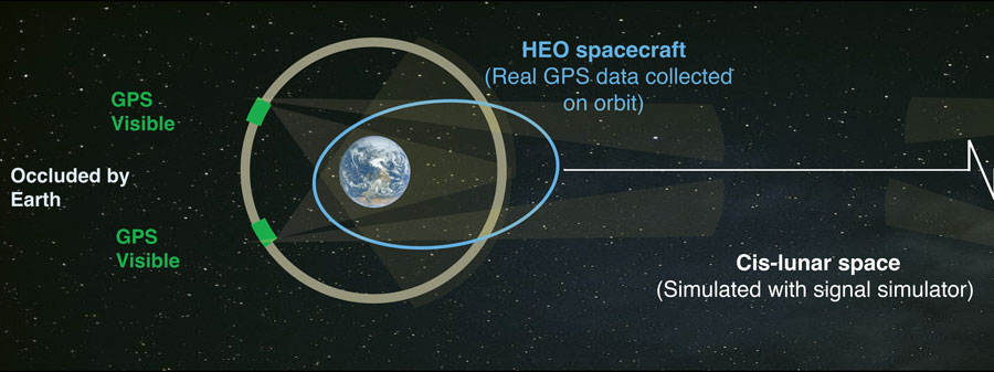
Read Richard Langley’s introduction to this article: “Innovation Insights: Falcon Gold analysis redux” As part of NASA’s increased […]

China’s BeiDou GNSS is newer, has more features, is more accurate, and has more satellites in the skies of more nations than the venerable U.S. GPS, according to Sarah Sewall, Executive Vice President for Strategic Issues at IQT.

“Seen & Heard” is a monthly feature of GPS World magazine, traveling the world to capture interesting and unusual news stories involving the GNSS/PNT industry.
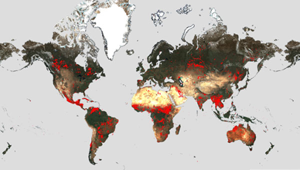
Wildfires have recently spread across Greece, Italy, Spain, Portugal, Algeria, Tunisia and Canada, causing mass environmental and economic […]

On June 13-15, GPS World contributor, David Zilkoski, had the privilege of participating in a working group event convened by the Geomatics Emerging Scientist Consortium for Education, Research and Capabilities Enhancement.


Follow Us