CHC Navigation introduces visual-lidar GNSS RTK receiver

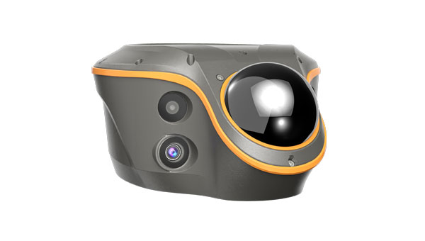
CHC Navigation (CHCNAV) has released the ViLi i100, its flagship visual-lidar GNSS RTK receiver designed for high-precision surveying in challenging environments. By integrating advanced GNSS signal processing, multi-sensor fusion with lidar and visual data, and refined positioning algorithms, the ViLi i100 offers consistent, centimeter-level accuracy, even where conventional GNSS receivers face limitations.
“The ViLi i100 is built to extend high-precision GNSS operation into challenging locations where traditional solutions reach their limits,” said Rachel Wang, product manager at CHCNAV. “By integrating visual-lidar, enhanced SFix positioning and multi-sensor fusion in one device, it enables professionals to maintain quality data capture without changing equipment or workflow.”
Powered by the enhanced SFix 2.0 engine, the ViLi i100 maintains 5 cm accuracy while moving within a 20 m radius in GNSS-denied environments. It utilizes 860,000 points per second of laser data with SLAM-based algorithms to reconstruct its position without direct reliance on satellite signals. This capability allows for uninterrupted work in tunnels, under viaducts or within deep construction zones, providing a continuous workflow.
The ViLi i100 is engineered for reliability in complex settings. It combines multi-sensor data to intelligently analyze satellite signal paths, automatically filtering out those affected by multipath interference. This process ensures stable, jump-free positioning, delivering consistent 5 cm absolute accuracy in environments such as narrow alleys, dense forests or near high-rise buildings.
The ViLi i100 integrates high-precision lidar sensing with intelligent processing to support real-time earthwork calculations directly on site. Users can define boundaries and receive immediate cut-and-fill or volume results with a high level of reliability, without the need for physical contact with the terrain. The contactless measurement capability enables safe and efficient data collection in hazardous or hard-to-reach areas, such as steep slopes, stockpiles or active construction zones, while maintaining consistent centimeter-level accuracy.


Subscribe to GPS World
If you enjoyed this article, subscribe to GPS World to receive more articles just like it.


Follow Us