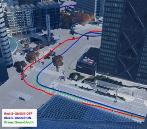
No audio available for this content.
We each arrived at our current involvement with the GNSS/PNT industry by a different path. For many, it was through engineering, perhaps initially thinking of focusing on completely different challenges than those posed by extremely weak RF satellite signals, intentional interference, or ionospheric scintillation. For others, it was through surveying, which they might have entered to make a living traipsing through open fields — well, traversing them — while working independently and in nature.
For others still, it was through one of the myriad applications of GNSS — from mapping the geographic distribution of the few remaining Amur leopards to guiding a tractor in the field, from commercial fishing in Alaska to conducting search and rescue missions, to training for military raids. Yet for others, it was through business, perhaps because they were tasked to route delivery trucks more efficiently or to track each vehicle in a rental fleet. Professor Richard Langley started out as an applied physicist and a radio tinkerer, building his first radio at the age of 14. My colleagues at North Coast Media got here via a career in journalism, with the steep subject-matter learning curve following their training in writing and editing.
I got here mostly through my passion for maps, charts and navigation. I first became interested in maps as a child — after twice getting lost. The first time, I was 5 years old and lost track of my mother as she entered a store in Berkeley, California, and I kept walking down the street. The next time, I was 7 and had insisted on walking home alone from school in Milan, Italy. I was determined not to let it happen again. So, when I was 11, I was the only kid I knew who walked around Pisa studying a map and a compass.
Next came the topographic maps I used for hiking. In my 20s, sailing around the Boston Harbor islands and off the coast of Maine, I learned to use nautical charts, sextants, radio direction-finders, sonar, radar, Loran C, and, finally, hand-held GPS receivers. I read my first technical article on GPS in 1985, when I was a graduate student in international security at MIT and Harvard, and the U.S. military was building the system. I studied its technical specifications and dreamt about its many possible future applications.
In 2000, when looking for a career change and a job in journalism, I saw a posting for the position of managing editor of this magazine. I applied and 25 years later I am still in the business.
Throughout, I always have been impressed by the deep expertise of the scientists and engineers who created this fantastic GNSS that billions of people use multiple times a day yet take for granted. Those who discount, belittle or even mock the expertise of people who have spent decades studying complex subjects — from climate change to economics, from foreign policy to epidemiology, from education to urban planning — are profoundly unaware and misguided, when not hypocritical. We need experts.