Listen to this content
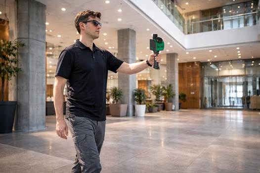
GeoCue has announced the upcoming release of the TrueView GO NEO, a handheld SLAM lidar system that expands the company’s TrueView handheld lidar product lineup.
Unveiled at Geo Week 2026 in Denver, The TrueView GO NEO adds a smaller, lighter, more portable option designed to make handheld mapping easier, more flexible, and more affordable, especially for indoor capture. It pairs with a smartphone, keeping the workflow streamlined and the total cost of ownership low.
Since introducing the original TrueView GO 116S and TrueView GO 132S handheld systems, GeoCue has seen rapid adoption of handheld mapping workflows across surveying, construction, public safety, facility documentation, and more. The new TrueView GO NEO extends that momentum with a rugged design and high performance for teams who need dense data and dependable SLAM in corridors, stairwells, mechanical rooms, and other GNSS-challenged environments.
Indoor mapping
The TrueView GO NEO was designed as a complete, end-to-end workflow, helping teams move quickly from data acquisition to usable results in complex indoor environments. At its core is a new high-rate scanning engine capable of capturing up to 1.15 million points per second, delivering dense detail while improving field efficiency. An ultra-wide field of view (360° × 189°) increases coverage overhead and helps reduce missed areas, so users can capture complete scenes faster without “painting” every surface.
The NEO also introduces Deep INS + SLAM Fusion, pairing SLAM mapping with a high-grade inertial navigation system to improve stability in feature-poor environments where typical consumer-grade navigation can struggle. The result is more reliable trajectories and improved point cloud integrity in challenging scenarios, such as long corridors and multi-floor stairwells, where drift and misalignment can degrade results.
To enhance interpretation and deliverables, the TrueView GO NEO includes HD colorization and advanced image capture to support panoramic imagery and detailed colorization even in low light. Users can also leverage these images to create visual outputs such as mesh models and high-fidelity reality renderings for downstream documentation and visualization workflows.
Paired with LP360 Land
TrueView GO NEO is paired with LP360 Land, GeoCue’s software for handheld lidar processing, QA/QC, visualization and deliverable creation. LP360 Land enables users to generate detailed point clouds from raw data, validate coverage and quality, and produce outputs aligned to project workflows without unnecessary complexity.
The NEO is also designed to keep workflows streamlined, pairing conveniently with a phone and supporting device-to-cloud options through the LP360 Cloud platform. Users can upload captured data over Wi-Fi or hotspot for automated post-processing or use an LTE-based workflow to upload data.
Highlights
- Smaller, lighter handheld SLAM lidar designed to “complete the range” of the TrueView GO lineup
- High-speed point capture for fast, dense indoor reality capture
- Ultra-wide field-of-view scanning to improve coverage and reduce blind zones
- Precision IMU for low-drift SLAM, supporting reliable results over longer sessions even in typical SLAM challenging conditions
- Integrated HD imaging for spherical capture and high quality colorization
- Built-in GNSS for georeferencing workflows when GNSS is available (RTK/PPK capable)
- “Smart Handle” integrating the battery with hot-swap battery capability for continuous scanning


