Listen to this content
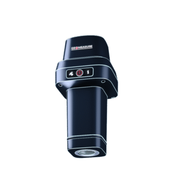
GEODNET, provider of a decentralized real-time kinematic (RTK) network, has launched GEO-MEASURE, a survey-grade GNSS rover that delivers centimeter-level accuracy at a consumer-accessible price.
For decades, survey-grade GNSS rovers have been essential tools for precision applications, but high costs and complex configurations have limited access to survey-grade GNSS rovers to large firms and specialized professionals. GEO-MEASURE is an affordable fully equipped RTK rover integrating robust hardware, a dedicated mobile app, and a preloaded RTK corrections service into a single turnkey package.
GEO-MEASURE is engineered for professional reliability with quad-frequency support across GPS, GLONASS, Galileo and BeiDou, Its 1,040 tracking channels provide resilience under canopy or in urban environments. Its rugged, waterproof housing is built for daily use, while a 24-hour rechargeable battery and USB-C charging make it as convenient as a consumer device while still delivering survey-grade performance.
Available for both iOS and Android, a free companion app simplifies setup, the company said. Once paired via Bluetooth, users can:
- visualize survey points on maps
- capture field notes
- manage multiple projects
- export data in standard formats (CSV, KML, GPX, GeoJSON) for integration with GIS platforms, CAD workflows, or drone mission software.
By making centimeter-level accuracy affordable, accessible and scalable, GEO-MEASURE opens professional-grade GNSS workflows to new audiences in construction, GIS, drone operations, agriculture and environmental monitoring.