Lehmann Aviation Tests LA300 Drone with Cameras

In 2013, Lehmann Aviation launched the LA300 — a fully automatic personal drone working with Nokia Lumia 1020 and Windows 8 Tablet and designed for mapping and DEM.
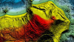
Flight tests in May have proven compatibility of the GoPro Hero3+ camera, in addition to Nokia Lumia 1020 41-Mp camera, with the LA300 for orthomosaics and digital elevation models (DEM), which makes this drone the an affordable and easy-to-use professional rugged solution for mapping and surveying, Lehmann Aviation said.
 LA300 is a fully automatic professional UAV designed for accurate mapping and surveying. To get the geo-referenced orthomosaics or DEM, the user needs to take three simple steps (watch the video below):
Step 1: Download the free Lehmann Aviation software — Operation Center — to any Windows 8 Tablet, Windows Phone 8, or PC.
Step 2: Make the flight path by drawing on a touchscreen Windows 8 device the area of interest (on the map) and entering the waypoints, after which the software will automatically generate the mission.
Step 3: Transmit the data to the drone by Wi-Fi, launch it by hand, and wait until the aerial robot returns to any chosen point with HD images or video on the SD card.
Step 4: Use Operation Center to geotag each image after the flight, with LAT/LONG/ALT/YAW/PITCH/ROLL information.
The pictures then can be processed in any popular orthomosaic/DEM software to generate professional orthomosaics and 3D models.
 The drone flies at a range of up to 15 km, at speeds of 20-80 km/h. It can be flown in harsh environments, between -25 °C up to +60 °C (-13 °F up to 140 °F), with winds up to 35 km/h (20kt). The LA300 weights 950 grams (including Nokia Lumia 1020 or GoPro Hero3+ camera), with a wingspan of 92 cm and the length of 45 cm. The drone is launched by hand and lands in a few meters of space.
All Lehmann Aviation drones come with one-year warranty and can be regularly upgraded to newer versions.


2 Comments on "Lehmann Aviation Tests LA300 Drone with Cameras"
Trackback | Comments RSS Feed
Inbound Links