Listen to this content
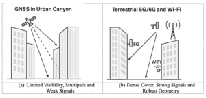
Maxar Intelligence is partnering with Taiwan’s Aerospace Industrial Development Corporation (AIDC) to deploy the Maxar Raptor software suite across Taiwan’s unmanned aerial vehicle (UAV) industry. The move will help the country accelerate the resilience and reliability of autonomous systems in GPS- and GNSS-denied environments.
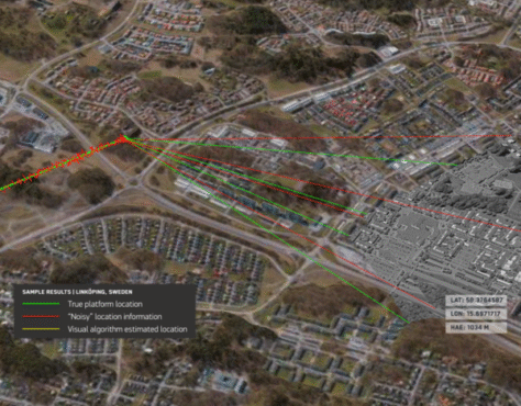
Raptor is a vision-based software suite that enables autonomous drones to navigate precisely and extract accurate ground coordinates in the absence of GPS. Designed for lightweight integration with any autonomous platform, Raptor products use a drone’s native camera and Maxar’s 100 million-plus sq km of global 3D terrain data to help the platform navigate with extreme precision and extract accurate ground coordinates in real-time without GPS. Raptor can operate at night and in low-altitude flight operations without the need for any additional hardware.
The partnership follows a successful field demonstration of Raptor software in Taiwan earlier this year, in which the test platform was able to maintain precise navigation under GPS-denied conditions using only its native camera and Maxar’s software.
The test platform was able to maintain precise navigation under GPS-denied conditions using only its native camera and Maxar’s software.
“Taiwan is rapidly building one of the most advanced UAV industries in the world, and AIDC is one of the companies leading the charge,” said Anders Linder, general manager, International Government at Maxar Intelligence. “Taiwanese UAV manufacturers are acutely aware of the importance of building resilience against GPS jamming, and AIDC has validated the unique capabilities of our Raptor software. By combining our geospatial intelligence with AIDC’s aerospace expertise, we’ll help Taiwan’s UAV industry maintain its forward momentum, accelerating autonomy across warfighting, humanitarian, and commercial operations.”
AIDC will drive the adoption of Raptor across Taiwan’s UAV supply chain and promote use of the software across the Taiwan Excellence Drone International Business Opportunity Alliance (TEDIBOA), an organization that AIDC chairs.
“This collaboration opens a new chapter for precision vision-based positioning in Taiwan’s UAV sector,” said AIDC President Chin-Ping Tsao. “We will jointly build a Taiwan-focused integration and testing center, highlight GPS-jamming resilience as a core differentiator, and unlock opportunities across Taiwan and the broader Asia market — advancing both defense resilience and commercial value.”