No audio available for this content.
My previous newsletter highlighted the Fall HSRP meeting that discussed how The Ohio State University and Michigan State University have made great progress in developing useful tools for the development and implementation of the new, modernized National Spatial Reference System (NSRS) in 2025. This newsletter will highlight the updates to vertical datums that The National Oceanic and Atmospheric Administration (NOAA) is working on.
My last newsletter described some of the activities of the National Ocean Service (NOS) program offices at the 2024 Hydrographic Survey Review Panel (HSRP) Fall Meeting. As I mentioned in last month’s newsletter, the Hydrographic Survey Review Panel is a federal advisory committee that provides NOAA with advice. The National Ocean Service program offices – National Geodetic Service (NGS), the Center for Operational Oceanographic Products and Services (CO-OPS), the Office of Coast Survey (OCS), as well as the University of New Hampshire’s Joint Hydrographic Center and Center for Coastal and Ocean Mapping, provide updates related to navigation services.
Below is an excerpt of the agenda for the material that I will highlight in this newsletter. As I mentioned in my last newsletter, the HSRP website provides links to reference documents, presentations and recordings. I would encourage everyone to download the presentations or listen to the recordings to obtain all the details.
This newsletter will highlight the session on the vertical datums, including the International Great Lakes Datum (IGLD).
Excerpt from HSRP Fall Public Meeting
Agenda: https://www.nauticalcharts.noaa.gov/hsrp/meetings/2024/fall-2024.html
Reference materials and links: National Geodetic Survey, A Tale of Three Datums
Presentations: Sept. 25, 2024;
1. Vdatum
2. International Great Lakes Datum (IGLD)
Webinar recordings:
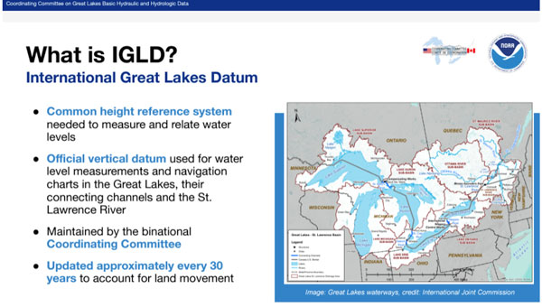
NGS has created a website that provides brief explanations with additional links for detailed information on the National Tidal Datum Epoch (NTDE), International Great Lakes Datum (IGLD) and Gravity for the Redefinition of the Vertical Datum (GRAV-D). The site highlights that NOAA is currently working on three major updates to vertical datums: the 1983-2001 NTDE, the International Great Lakes Datum of 1985 (IGLD 85), and the North American Vertical Datum of 1988 (NAVD 88). The site provides information on why the datums need to be updated.


The box titled “Excerpt from NTDE“ provides information about the NTDE. It explains what the NTDE is, what NOS is doing, and why the NTDE needs to be updated. If you click on the link titled “National Tidal Datum Epoch update” on the right side of the webpage, it provides more information and links about the NTDE update, such as how will the NTDE update impact you.
The following is an exerpt from the National Tidal Datum Epoch update:
National Tidal Datum Epoch
The National Tidal Datum Epoch (NTDE) is a 19-year time period established by the National Ocean Service for collecting observations on water levels and calculating tidal datum values (e.g. mean sea level, mean lower low water). The NTDE needs to be regularly revised to account for long-term effects of land movement, sea level rise, and changes in tidal constituents. Tidal datums and their data are used to generate products and services necessary for safe navigation, coastal hazard mitigation, ecosystem research, coastal engineering and marine boundary demarcations.
The NTDE Update: New Tidal Datums are Coming!
NOAA currently utilizes the 1983-2001 National Tidal Datum Epoch. This epoch is now undergoing revision and will be replaced by the fifth iteration of the NTDE. Measurements for the update will be based on water level data spanning the years 2002-2020. Once all data has been collected, NOAA will review, analyze, and generate revised datums. The current proposed release date for new NTDE products is after 2026.
The website also highlights two other NOS projects – the International Great Lakes Datum and the Gravity for the Redefinition of the Vertical Datum (GRAV-D). Again, if you click the “International Great Lakes Datum update” link on the right side of the webpage, it provides more information and links about the IGLD update such as how will the IGLD update impact you. Clicking the “Gravity for the Redefinition of the Vertical Datum” link on the right side of the webpage provides some more information and links about vertical datums.


On the second day of the meeting, Jacob Heck, NOAA National Geodetic Survey (NGS), and Sierra Davis, NOAA Center for Operational Oceanographic Products & Services (CO-OPS), gave a presentation providing details on the update to the International Great Lakes Datums of 1985 (IGLD 85). The presentation addressed the following topics:
- Define IGLD
- Significance of the Great Lakes and need for a common water level datum
- Binational coordination and mandates
- Why IGLD needs to be updated
- Updating the datum
- Crucial observational infrastructure
- Differences in IGLD (1985) and IGLD (2020)
- Future of accessing the datum
- Status of IGLD (2020) development
- Project milestones to roll-out
- Unresolved questions: low water datum
- Outreach efforts underway
I have provided a few slides highlighting parts of the presentation. Again, the HSRP website provides links to reference documents, presentations, and recordings. I would encourage everyone to download the presentation or listen to the recording to obtain all the details. The presentation of the IGLD starts at 1:34:00 on the recording.

They explained the importance of the requirement for the coordination of water levels on the Great Lakes between Canada and the United States and the reason for establishing an international datum.

Due to land deformation, the IGLD is periodically updated, typically every 25 to 30 years. That is, an uplift in the northern region and subsidence in the southern region of the Great Lakes. See the box titled “Land Deformation in the Great Lakes.”

The IGLD was updated in 1955 and then again in 1985. This update is overdue by a few years. That said, it will be aligned with the new modernized NSRS and allow for more seamless updates in the future.

The presentation highlighted that the expected changes between the old datum, IGLD 85, and the new datum (IGLD 2020) will range from 30 cm to 65 cm.

The IGLD community measures hydraulic heads for water management using dynamic heights, not orthometric heights. The presentation explained why IGLD uses dynamic heights and how GNSS technology will be used to estimate IGLD dynamic heights.


The IGLD team have been working on getting the message out to the user community. The September 2024 HSRP presentation is just one example. Here’s a summary of the recent and future outreach activities:
Recent engagements:
- All-Interested Congressional briefing (May 2024)
- Canadian Hydrographic Conference (May 2024)
- Canadian Geophysical Union Conference (May 2024)
- IAGLR (May 2024)
- Soo Locks Engineers Day (June 2024)
- Michigan Sea Grant briefing (Jan 2024)
- Illinois Coastal Management Program briefing (Sept 2024)
Upcoming:
- Coordinating Committee’s ESG (TBD)
- Boards of Control (Spring 2025)
- 2024 Great Lakes Conference, Chicago, IL
- US Hydro 2025, Wilmington, NC
- IAGLR 2025
The slide titled “Key Takeaways” summarized the essence of their presentation.

Click here to view the full presentation.
Resources
- Coordinating Committee IGLD Website: https://www.greatlakescc.org/en/international-great-lakes-datum-update/
- NOAA CO-OPS’ IGLD Website: https://tidesandcurrents.noaa.gov/datum-updates/igld/index.html
- Modernized NSRS: https://geodesy.noaa.gov/datums/newdatums/index.shtml
- Reference System Updates in Canada: https://natural-resources.canada.ca/maps-tools-and-publications/geodetic-reference-systems/height-reference-system-modernization/9054
This newsletter highlighted NOS’s Tail of Three Datum website. The website provides brief explanations with additional links for detailed information on the National Tidal Datum Epoch (NTDE), International Great Lakes Datum (IGLD), and Gravity for the Redefinition of the Vertical Datum (GRAV-D). The site highlights that NOAA is currently working on updating the 1983-2001 NTDE, IGLD 85, and North American Vertical Datum of 1988 (NAVD 88). The newsletter also discussed the presentation on the International Great Lakes Datum (IGLD) 2020 that was given at the 2024 Fall HSRP meeting. Again, the HSRP website provides links to reference documents, presentations, and recordings. I would encourage everyone to download the presentations or listen to the recordings to obtain all the details.