Listen to this content
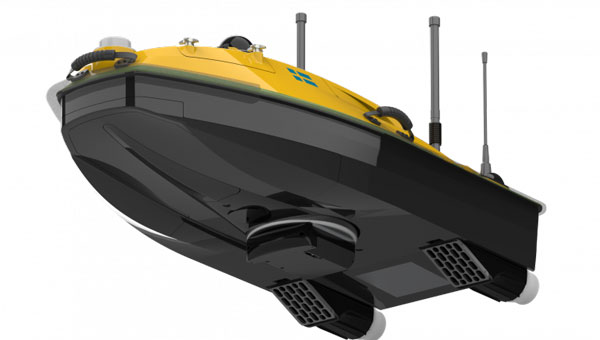
SatLab has introduced the HydroBoat 1200MB, a compact uncrewed surface vehicle (USV) system engineered for 3D hydrographic surveying in inland and nearshore waters. The system integrates SatLab’s autonomous vessel platform with the HydroBeam M2 multibeam echosounder, providing a portable solution intended to streamline data collection in shallow or confined environments.
The HydroBoat 1200MB is developed as a fully integrated unit, combining navigation, sonar data acquisition, real-time visualization and data management. According to the company, it is designed to assist small teams in conducting geospatial reconnaissance and hydrographic assessments with minimal setup and reduced operational complexity.
SatLab reports that the system supports a seamless workflow, from survey planning through to the delivery of final results. The vessel features an integrated inertial navigation system that delivers roll, pitch and yaw measurements without requiring field calibration. Its real-time data visualization capabilities allow users to view high-resolution 3D point clouds, bathymetric profiles and sidescan imagery across multiple devices, which allows for immediate quality control and decision-making in the field.
The HydroBoat 1200MB incorporates SatLab’s proprietary sound speed profile inversion technology, which enables real-time sound velocity correction without the need for separate sound velocity profilers. The system is designed for operational efficiency, with deployment possible in under five minutes and control managed through an Android-based interface.
Equipped with a multibeam configuration offering 512 beams and a swath coverage of 30 to 150 degrees, the HydroBoat 1200MB is intended to allow users to survey larger areas compared to singlebeam alternatives. According to SatLab, this configuration can result in up to a 7.5-fold increase in survey efficiency and potential cost reductions of up to 50%, due to the elimination of auxiliary equipment and simplified field operations.
The HydroBoat 1200MB can be used in a variety of applications, including river and reservoir surveys, bank mapping, structural inspections, sediment transport monitoring and infrastructure assessment. It is designed to meet data quality standards set by the International Hydrographic Organization, the Canadian Hydrographic Service and the U.S. Army Corps of Engineers.