Listen to this content
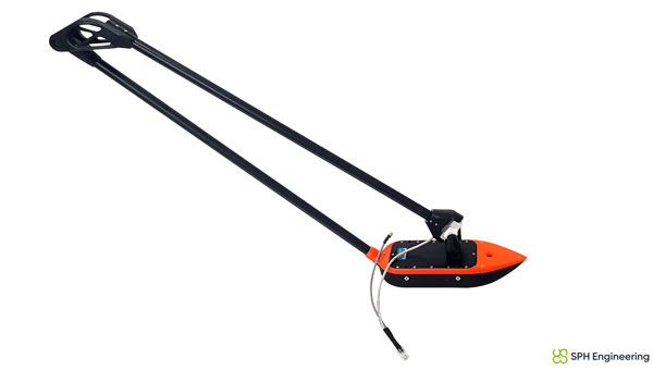
SPH Engineering has released a multibeam echosounder system for UAVs that uses the Cerulean Surveyor 240-16, a compact bathymetric sensor designed for shallow-water mapping.
The system expands drone-based hydrographic surveying capabilities by providing high-resolution bathymetric data collection over shallow waters. The Surveyor 240-16 operates at 240 kHz with a measurement range of 0.5 m to 50 m, targeting inland waterways, reservoirs, ports and environmental monitoring locations.
The multibeam system generates an 80° cross-track swath with a 16-element receive array and 1° angular resolution, allowing operators to map wider bottom coverage compared to traditional single-beam payloads.
The payload integrates with SPH Engineering’s UgCS flight planning software and SkyHub onboard computer for automated missions. Weighing 2.4 kilograms with all components and consuming 15 watts of power, the system works with UAVs including DJI M300, M350 and M400 models, as well as Inspired Flight IF800 and IF1200 aircraft.
SPH Engineering conducted field validation at Titutga Lake in Latvia in August 2025. Survey flights operated at an average speed of 1.2 m per second, balancing data collection density with UAV battery endurance.
Testing compared the multibeam system’s performance against single-beam payloads, which engineers noted remain useful for quality control verification of multibeam datasets. The combined approach demonstrated capabilities for high-resolution mapping in areas previously difficult to access with boat-based systems.
Software compatibility includes full support in BeamworX, with Hydromagic integration planned for future releases.
“The payload based on Cerulean Surveyor 240-16 represents a milestone in drone-based bathymetry,” said Alexey Dobrovolskiy, CEO of SPH Engineering. “By combining multibeam technology with UAV platforms, we are enabling hydrographers to collect dense bathymetric datasets at a fraction of the time and cost of conventional systems. This integration opens new opportunities for surveying reservoirs, lakes, and coastal areas that were previously inaccessible or unsafe.”


