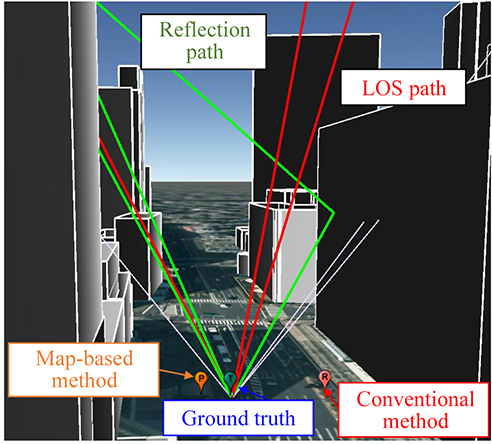
Skip to content

TAG: 3D mapping

Image: Delair

Delair offers advanced UAV for aerial surveying and mapping

February 5, 2018

This article is tagged with , , , , , , , and posted in Latest News, Mapping, Survey, UAV/UGV
1
Above: The constructed 3D model for 26 buildings; below: illustration of the direction of recording of surfaces. (Images: Authors)

Research Online: Urban positioning accuracy enhancement using 3D buildings model

December 26, 2017

2
Photo: YellowScan

Velodyne partners with YellowScan for UAV lidar system

October 31, 2017

3

Harnessing scan-to-BIM technology on historic sites

August 23, 2017

4
Image: GPS World

Global Mapper update improves 3D tools

February 24, 2017

This article is tagged with , , , and posted in GIS News, GIS Software, Technology
5
Photo: Chris Pucci

Oregon moves to tablets for no-stake 3D

February 8, 2017

This article is tagged with , , , , , and posted in From the Magazine, Latest News, Survey
6
photo: www.ecapture.es

Launchpad: OEM, survey and mapping products

June 3, 2016

7
Image: GPS World

Recreating Singapore in 3D

December 22, 2015

This article is tagged with , , and posted in Featured Stories, GIS News, GIS Software, Mapping, Technology
8