Launchpad: OEM, survey and mapping products
June 3, 2016
OEM Module for system integrators Size, weight and power designed for smaller unmanned platforms The MB-Two GNSS module […]
Read More

OEM Module for system integrators Size, weight and power designed for smaller unmanned platforms The MB-Two GNSS module […]

The Singapore Land Authority (SLA) is engaged in a 3D mapping initiative to create and maintain a high-resolution […]

The U.S. Geological Survey National Geospatial Program is developing the 3D Elevation Program (3DEP) to respond to growing […]

Esri has released ArcGIS 10.3.1, bringing new capabilities. Smart Mapping is an innovative approach for creating maps that […]

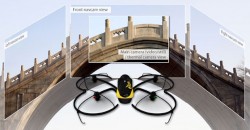
Swiss professional drone maker senseFly has launched the eXom, its new quadcopter UAS for mapping and inspection. The eXom is available […]

Topcon Positioning Group has announced the latest edition of its 3D mobile mapping system. The IP-S3 employs the integration of an inertial measurement unit (IMU) and GNSS receiver with a vehicle’s onboard electronics to offer high-density mobile digital imaging.
Agency9, a provider of online 3D visualization, is extending its 3DMaps WebGL support to iOS and Android devices. […]
Follow Us