Bluesky with CityMapper captures cities in 3D
January 9, 2019
Aerial survey company Bluesky International Ltd. is using the Leica CityMapper to capture major cities throughout the United Kingdom.
Read More
Aerial survey company Bluesky International Ltd. is using the Leica CityMapper to capture major cities throughout the United Kingdom.
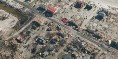
SimActive Inc., developer of photogrammetry software Correlator3D, has partnered with Midwest Aerial to perform damage assessments of Hurricane […]

A real-time system combining a simulator and a GNSS propagation model reproduces an authentic multipath environment. The propagation model relies on a 3D-model reconstruction of the urban environment, which generates a multipath signature strictly dependent on the location of the receiver’s antenna. This yields important results for a moving vehicle, which may be affected by very different multipath conditions depending on trajectory and location.
During my tenure as the GIS manager for the Atlanta Regional Commission, I had the opportunity to work […]
When Philadelphia welcomed Pope Francis during his September visit, Bentley Systems’ 3D reality modeling tools helped the event […]
Lorenzo Martelletta of PIX4D gives an overview of the company’s Pix4D image processing software while at INTERGEO 2015, […]
Data from Topcon’s participation in the digital preservation of the historic Sogi hydroelectric plant in Japan was unveiled at […]
Icaros Inc., a provider of advanced aerial remote sensing and 3D visualization solutions, will demonstrate the Icaros Measurement […]


Follow Us