
Esri unveils CityEngine mobile virtual reality solution
February 6, 2017
Esri has released a virtual reality (VR) solution for CityEngine, the company’s 3D modeling software. The newest version of […]
Read More
Esri has released a virtual reality (VR) solution for CityEngine, the company’s 3D modeling software. The newest version of […]
A tight coupling of GNSS and inertial measurements is needed for both accurate and reliable positioning. The use of multi-GNSS is recommended to obtain a sufficient number of visible satellites in any outdoor environment.
The Open Geospatial Consortium (OGC) is considering start of a new work item for a Community Standard: Indexed […]

Xsens has launched BASE, an online technology platform with a community forum and a knowledge base on 3D […]
GeoMobile Innovations has released GeoBullseye for ArcPad version 2. GeoBullseye is a software extension that turns Esri’s ArcPad mobile […]
Topcon Positioning Group has released a new 3D dozer machine control system — 3D-MCMAX. The system is driven by […]
REAL 2015: Capture, Compute, Create will be held Feb. 25–26 at Fort Mason Center in San Francisco. REAL is designed […]
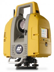
Topcon Positioning Group announces the release of the newest edition to the GLS line of laser scanners, […]


Follow Us