EASA, IATA release 4-point plan to mitigate GNSS interference risks
October 13, 2025
The plan was among the conclusions of a jointly hosted workshop on the topic of GNSS interference.
Read More

The plan was among the conclusions of a jointly hosted workshop on the topic of GNSS interference.

A five-year research and development program has been launched to enhance GNSS navigation for aviation, encompassing security, integrity […]

SandboxAQ and Acubed, the Silicon Valley innovation center for Airbus, have released real-world test results from a five-month, nationwide project.

SeRo Systems is expanding its portfolio with the launch of its newest monitoring technology for improved aircraft
situational awareness.

Martin Faga sheds light on the early days of the GPS program, including the attempts to halt it in the early 1980s. He emphasizes the significance of being able to navigate easily and accurately and have precise time, not only for military operations but also for civilian life.

The Radio Technical Commission for Aeronautics (RTCA) has released a six-file document titled “DO-401 Minimum Operational Performance Standards (MOPS) for Dual-Frequency Multi-Constellation Satellite-Based Augmentation System Airborne Equipment.”

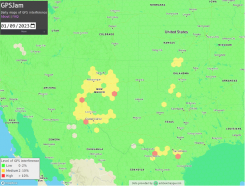
GPSJam.org has shown regular interference with GPS signals in Texas near San Antonio and Del Rio, and locations north and south of Oklahoma City, Oklahoma.
Follow Us