CHC Navigation introduces BB4 UAV and AlphaUni lidar combination
June 23, 2020
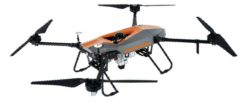
Lidar series paired with professional drone provides multi-platform, high-accuracy 3D laser scanning for geospatial and mapping professionals CHC […]
Read More
Lidar series paired with professional drone provides multi-platform, high-accuracy 3D laser scanning for geospatial and mapping professionals CHC […]

China’s field work for new measurements of Mount Everest — the world’s, highest peak — are now complete. […]

CHC Navigation’s P5 geodetic GNSS receiver was successfully used by a Chinese team of surveyors to complete the […]
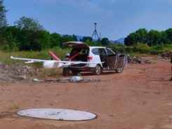
The CHCNAV P330 vertical takeoff and landing (VTOL) UAV has been deployed to complete orthophoto acquisition with a […]


Follow Us