
Geologist uses lidar to monitor Greenland Glacier ice loss
November 30, 2017
Leigh Stearns, a geologist with the University of Kansas, is working with a Riegl VZ-6000 ultra long range […]
Read More
Leigh Stearns, a geologist with the University of Kansas, is working with a Riegl VZ-6000 ultra long range […]

In life, few things are certain. In family, love and friendship, fewer. Add more people — workplace, groups, […]
The Washington Post reported March 3 that the Trump administration proposes slashing the budget of the National Oceanic and Atmospheric […]

New weather datasets, which could prove highly valuable for weather forecasting and for longer term climate monitoring, have […]
The Arctic SDI Board, — which includes mapping executives from Canada, Kingdom of Denmark, Finland, Iceland, Norway, Russia, […]
Esri has released an interactive map illustrating the earth’s natural and human systems and how they have changed — […]
Esri has unveiled a Human Health and Climate Change App Challenge, calling on the worldwide GIS community to create […]
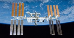
A new concept that involves mounting an instrument on the International Space Station and taking advantage of signals from navigation satellites could provide measurements of sea-surface height and information about features related to ocean currents, benefiting science and ocean forecasting.


Follow Us