Analysis of satellite imagery shows reduced NO2 in China, Italy
March 23, 2020
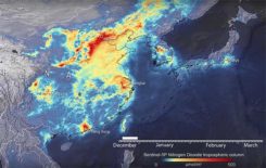
Descartes Labs, a geospatial data analytics company, is using satellite imagery analysis to examine how the coronavirus reduced […]
Read More
Descartes Labs, a geospatial data analytics company, is using satellite imagery analysis to examine how the coronavirus reduced […]
The months-long wildfires raging in Australia have killed at least 25 people. Millions — possibly 1 billion — […]

The new GSA GNSS Market Report is now available for download. The report provides a comprehensive overview of […]
News from the European Space Agency Less than two weeks after it was launched, the Copernicus Sentinel-3B satellite […]
The Airbus-operated SpaceDataHighway has begun regularly relaying data from the Sentinel-2A satellite, after the successful end of the […]

The Sentinel-2B satellite was launched for the European Commission on Monday, March 6, at 10:49 p.m. local time from […]

A Kingdom Divided: Whither EU Space Programmes? Good grief, it has been a wild week or two. I […]
The U.S. Geological Survey (USGS) and the European Space Agency (ESA) have established a partnership to enable USGS […]


Follow Us