Analysis of satellite imagery shows reduced NO2 in China, Italy
March 23, 2020
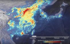
Descartes Labs, a geospatial data analytics company, is using satellite imagery analysis to examine how the coronavirus reduced […]
Read More
Descartes Labs, a geospatial data analytics company, is using satellite imagery analysis to examine how the coronavirus reduced […]
Vexcel Imaging, a provider of aerial imagery data, large-format aerial cameras and photogrammetry software, has signed a definitive […]

Komatsu America Corp. and Propeller Aero Inc. are partnering to boost the efficiency of construction job sites using […]
A new book on open-source geospatial information systems (GIS) will be published in May. Information on the book […]
Esri has awarded Microsoft Corporation with the New Technology Integration Award at the Esri Partner Conference in Palm Springs. […]
From bioterrorism to natural disaster emergency management, predictive analytics used with geospatial tools and Big Data is proving to be a powerful new intelligence tool that may help counter global threats.
PoLTE Corporation has developed technology that harnesses the global long-term evolution (LTE) deployment to provide accurate and reliable […]


Follow Us