Skip to content

TAG: David B. Zilkoski

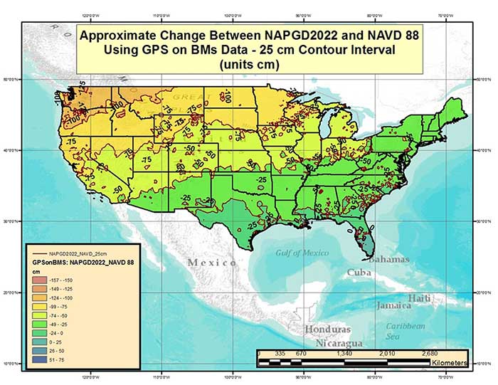
Figure 1 – Approximate Change Between NAPGD2022 and NAVD 88 Using GPS on BMs Data (units = cm). (Image: National Geodetic Survey)

Discussing the new North American-Pacific Geopotential Datum of 2022 — Part 1

June 7, 2017

1
Source: GPS World

A look at NGS’ GPS on benchmarks program in Alaska

April 5, 2017

This article is tagged with , , and posted in Opinions, Survey
2
Source: David B. Zilkoski

Establishing orthometric heights using GNSS — Part 11

February 1, 2017

This article is tagged with , , and posted in Opinions, Survey
3
chart: Rowan County height differentiation

Establishing orthometric heights using GNSS — Part 8

August 3, 2016

4
Figure 1. Leveling Network Design Used in the General Adjustment of the North American Vertical Datum of 1988 (Figure 3 from the report).

Establishing orthometric heights using GNSS — Part 7

June 2, 2016

5
Image: GPS World

Establishing orthometric heights using GNSS — Part 6

April 6, 2016

6
Image: GPS World

Establishing orthometric heights using GNSS — Part 4

December 2, 2015

7
A depiction of the United States geoid. Areas in yellow and orange have a slightly stronger gravity field as a result of the Rocky Mountains.

Establishing Orthometric Heights Using GNSS — Part 3

October 7, 2015

8