IIT Roorkee offers free online course on GNSS and DEMs
May 19, 2021
The Indian Institute of Technology (IIT) Roorkee is offering a free online course on GNSS and Applications on […]
Read More
The Indian Institute of Technology (IIT) Roorkee is offering a free online course on GNSS and Applications on […]
RedTail Lidar Systems partnered with an engineering firm to demonstrate the RTL-400 lidar system’s high-resolution, high-accuracy mapping capability. […]
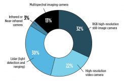
New sensing and software tech spurs growth While UAVs are an exciting new technology for mapping, most respondents […]

Esri is releasing Sentinel-2 Image Services to all Esri users for no additional cost. According to the company, […]
Drone-maker 3DR is teaming up with Esri to integrate 3DR’s Site Scan software with Esri Drone2Map. 3DR made the announcement at […]
Today at the Esri User Conference, 3DR announced that it has teamed up with Esri to integrate 3DR’s […]
Icaros Inc., a provider of aerial remote sensing services and software, has announced that Harris Geospatial Solutions, a […]
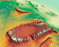
Wilpena Pound, shown above, is a natural amphitheater of mountains in the heart of Flinders Ranges National Park […]


Follow Us