Esri provides mapping software for organizations fighting COVID-19
March 20, 2020
Communities in need of resources can access location intelligence technology at no cost with six-month trial Location intelligence […]
Read More
Communities in need of resources can access location intelligence technology at no cost with six-month trial Location intelligence […]

Jeremy Kirkendall, senior GIS administrator for the NASA Disasters Program, gives GPS World an overview of the program […]
High-resolution airborne lidar data to be acquired over 34,000 square miles for disaster response and recovery. Under an […]
DigitalGlobe has released pre- and post-event satellite imagery of the areas in India affected by heavy flooding. According […]
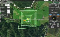
UgCS, a provider of mission planning software for unmanned aircraft systems (UAS), and public safety and disaster response […]
The Open Geospatial Consortium (OGC) is hosting the second Disasters Concept Development Study Workshop July 24-25 at the […]
TCarta, a global provider of marine geospatial products, has delivered pre- and post-disaster surface models for the Caribbean […]

By Simon Batzdorfer, Markus Bobbe, Martin Becker and Ulf Bestmann, Technische Universitaet Braunschweig All images courtesy of the […]


Follow Us